To see around
See more
Open
Close
Show
Show
Show
Show
Show
Show
Show
Show
Show
Show
Show

Oups... It would appear that Cirkwi does not have permission to use your location.

Description
Map
Steps
Points of interest
Ratings and reviews
See around

The Malaine track

The Malaine track
The Malaine track

Description

84 switchbacks and 700m of height loss over 2.5 km. These three figures sum up this descent, which is one of the finest in the Oisans region. One bend leads immediately to another. Starting in Oulles, the track winds its way through the heart of an ancient beech wood.

Route in the “MTB in Oisans” guide (Oisans Tourisme)

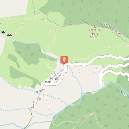
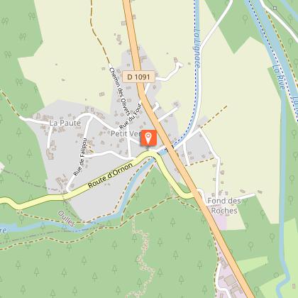
Departure: Oulles 1400 m
Arrival: La Paute 720 m
Time: 1 h
Distance: 6 km
Highest point: 1417 m
Lowest point: 720 m
Total ascent: 30 m
Total descent: -700 m
Technique: 3/4
Endurance: 2/4

Map: Top 25 Grenoble 3335 OT

ROUTE
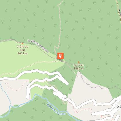
> From Oulles, follow signs for ‘La Malaine, plaine du Bourg’ and ride to Le Piret (1401 m) next to an electricity pylon.
> You’re now all set for the La Malaine descent!
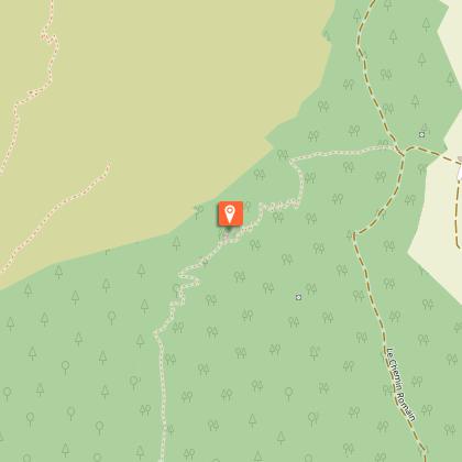
> You immediately plunge into a thick forest of beech trees (remember to take clear glasses for the dark woods) on a narrow, fast path, running alongside the mountain. Take care on the traverses as it’s easy to gather speed and you never know what is hidden under the leaves (stones, roots, branches, etc.).
> The descent then begins, with a rapid succession of switchbacks... so long as you have the skills, it will all be alright!
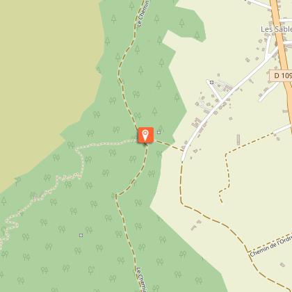
> The route finishes on a fast, straight section that comes out onto a track. Turn right for an easy ride back to the hamlet of La Paute.

Technical informations

This circuit was updated on: 13/04/2024
6 km
1 h
max. 1420 m
min. 712 m
30 m
700 m

Accessibility

Style : Mountain
Public : Reserved for experts/confirmed

Altimetric profile

Starting point

Grand Champ , 38520 Oulles
Lat : 45.073735Lng : 5.981969

Points of interest

image du object

La voie de Rochetaillée

Rochetaillée lierally means "cut rock" in French and looking up at the road carved out of the cliff face, it is clear how the village got its name. However, the exact origin of this road appears lost in the folds of history.Is this road, as many people believe, the remains of a Roman road, the indelible mark of an unstoppable sovereign population? Or, as Doctor Roussillon suggests in his Traveller's guide to Oisans, is it "the still visible trace of a path created during the existence of the lake, along the bottom of the neighbouring mountain and behind the small hamlet of Rochetaillée, from which it draws its name. Such were the circumstances in which this path was built." An observor at the end of the 19th century reported certain similarities beween the Porte des Bons and the Rochetaillée road, suggesting a close correlation between the two. Marks and tracks on the ground were reported to be similar and of exact equal width. Unfortunately, no trace of these marks has been found since and the campaign to clear and clean the site carried out by in 2004 by "Customs and Traditions of Oisans" also failed to uncover any evidence. To better understand this, it needs to be remembered that in the last century, the plain through which the road passes was like a desert without any vegetation. Both the cliff and the plain were completely bare, meaning that it was no doubt easy at the time for witnesses to observe and note the smallest details. These days, the road is virtually covered by vegetation and in some places, you can almost walk past without noticing it. But why carve the road out of the rock? If we go along with Docteur Roussillon's theory, the creation of Saint-Laurent lake would be the only tangible reason for this project, which must have involved considerable manpower and resources. The other theory, if we consider this to be a Roman road, suggests that any rapid progress towards the high mountain passes was hindered by the neighbouring plain. Perhaps it was a swamp or a lake that was liable to flooding due to the unpredictable behaviour of the Romanche river? The size of the project to build the road would also prove the importance of the "Oisans way" in the eyes of the Romans. Along the entire length of the platform, rectangular markings are carved out of the stone at regular intervals. These suggest that a structure consisting of beams and a wooden floor covered the road, widening it from 2 metres to 3 or 4 metres and making for easier progression. At suitable points, wider platforms were installed, known as "garages" that served as passing places for animals and carts. To this day, the track linking Rochetaillée to Bourg d'Oisans, via the hamlets of La Paute and Les Sables, is known as the "Chemin Romain". Source: Freneyd'Oisans.com/Mr Albertino

- Oisans Tourisme -
Consulter
image du object

Village d'Oulles

Oulles is one of the smallest villages in the Alps, with fewer than a dozen year-round residents. Nestling at the top end of a valley, it offers breathtaking views over the Grandes Rousses, the Meije and the Barre des Ecrins.If you climb a little higher above the village, you will be rewarded with an even greater view. Located at an altitude of 1400 m on the Massif du Taillefer, Oulles Is the least populated village in Isère. The road leading up to the village is a sign of the sheer steepness of the surrounding mountains. Locals even say that it is so steep around Oulles that the inhabitants used to shoe their chickens! But it all adds to the charm of the village. Oulles has only been accessible to vehicles via this road cut into the rockface since 1963. Immense effort was required to claw back these 7 kilometres of switchbacks from the mountainside - a miracle to create a path out of such a steep mountainside. All this gives you an idea of this incredible road that leads to the little village of Oulles, intact and with unspoilt charm, looming out of the past… (The road is narrow and winding, so drive carefully). A wide range of mountain activities can be enjoyed in Oulles. Cycling, for example, up the 7 km of switchbacks, although the climb is very pleasant on this wooded mountainside, protected from the wind. Hiking with the family on the path to Ornon or slightly more challenging hiking up to the Taillefer mountain hut, as well as the Grand Galbert, Lac du Poursollet, the summit of the Taillefer, Lac Fourchu, Puy d'Oulles and others. All this can also be explored and enjoyed in winter on snow shoes and ski touring. Last but not least, a mountain biking path starts from the village on the Chemin de Malaine, although it is suited to experienced mountain bikers, as there are 84 switchbacks over the 680 m descent! For more information if the 'Mairie' is closed, please contact the Bourg-d'Oisans tourist office.

- Oisans Tourisme -
Consulter
image du object

Le Piret from Oulles - Hiking

- Oisans Tourisme -
Consulter
image du object

Route d'exception : La route d'Oulles

Oulles, en Oisans, est l'un des plus petits villages des Alpes. Ce tout petit village niché dans un cul de sac bénéficie d'une vue à couper le souffle : Les Grandes Rousses, la Meije, la Barre des Écrins.En montant un peu au-dessus du village la vue s'ouvre encore. Situé sur le massif du Taillefer, à 1400 m d'altitude, Oulles est la commune la moins peuplée du département de l'Isère. La route donne le ton, le pays est très raide. Dans la région, on raconte qu’à Oulles, il y a tellement de pente qu’on y ferrait les poules ! Et c'est peut-être là tout son charme. Oulles n’est desservie par une voie carrossable taillée dans la roche que depuis 1963. 7 km d’épingles gagnés à la montagne, au terme d’efforts incommensurables pour trouver un chemin dans cette verticalité. Cela vous donne une idée de cette route incroyable sur ce versant boisé et protégé du vent qui permet d’accéder au petit village d’Oulles, intact, au charme préservé, comme surgi du passé… (Route étroite et sinueuse, conduisez prudemment) A Oulles on retrouve les principales activités de montagne ; cyclisme, randonnée familiale ou sportive, raquette et ski de randonnée, VTT

- Oisans Tourisme -
Consulter

Date and time

  • From 01/06/2024 to 31/10/2024
  • From 01/06/2025 to 31/10/2025

Additional information

Updated by

Oisans Tourisme - 08/04/2024
www.oisans.com
Report a problem

Environments

Mountain location

Open period

From 01/06 to 31/10.

Subject to favorable snow and weather conditions.

Contact

Phone : 04 76 80 03 25

Email : info@oisans.com

Website : www.bike-oisans.com

Topo guides and map references

Topo guides references :
Route in the “MTB in Oisans” guide (Oisans Tourisme)

Map references :
Top 25 Grenoble 3335 OT

Location complements

From Le Bourg-d’Oisans, take the D1091 towards Grenoble and then the Col d'Ornon. After 1.5 km, turn right onto the road for Oulles. By car, this takes around 20 minutes and you can park at the exit to the village.
Another option involves leaving the car at La Paute (the junction of the D1091 and the D526) and cycling the 8km up to stretch your legs a bit. This road is as quiet as a rural track and the scenery is magnificent.

Data author

Image Oisans Tourisme
proposed by Oisans Tourisme
1 bis rue Humbert 38520 Le Bourg d'Oisans France

Ratings and reviews

To see around
See more
Open
Close
Show
Show
Show
Show
Show
Show
Show
Show
Show
Show
Show