The Grand Tour of La Grave Villar-d'Arène
Description
A classic cross-country route, this lovely loop takes you through all the hamlets of La Grave. On a balcony path on the south facing slopes of La Grave, you have the very best view of La Meije and its glaciers.
Itinerary from the “MTB in Oisans” guide (Oisans Tourisme)
Departure / Arrival (loop): La Grave 1450 m
Time: 3 1/2 hours
Distance: 30 km
Highest point: 2069 m
Lowest point: 1438 m
Total ascent: 1109 m
Total descent: -1109 m
Technique: 3/4
Endurance: 3/4
Map: IGN Top 25 Valloire 3435 ET and Meije Pelvoux 3436 ET.
ROUTE
> This route from La Grave, Chazelet or Villar d’Arène is marked FFC (n ° 8 - The grand tour of the canton).
> From the Bureau des Guides in La Grave take the main road to the right until you reach the end of the village. Turn right on the little road leading down to the
Arboretum. Cross the bridge and take tha path to left that follows the river up to Villar d’Arène.
> Once in Villar d’Arène, from the square in front of the church (Place de l’église), ride up the right-hand street (wrong way up the one-way street), that turns into a path a few hundred metres further on. This goes to the narrow road leading to Le Pied du Col.
> Once in the hamlet, you can take a detour via the Pas de l’Ane and the gravel quarry. Once back in Le Pied du Col, take the path leading up to Les Cours.
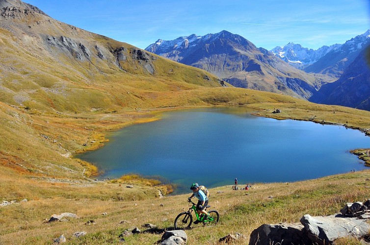
> In Les Cours, turn right up the path leading to the Lac du Pontet (track for 1 km, road for a further 2.5 km and then a steep path). Ride around the lake on the left-hand side and take another steep path which turns into a magnificent single track that joins l’Aiguillon (2060 m). This marks the start of a fine downhill section to Entraigues / Valfroide.
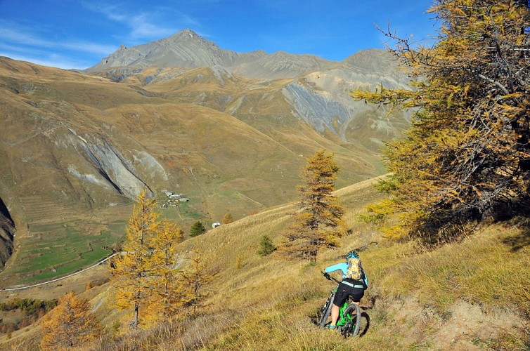
> Cross over the bridge and follow the track and then the road to Valfroide, Les Hières and then Ventelon.
> Once in Ventelon, take the track most to the right up to the hamlet of Les Clots. If you wish to shorten the ride, you can join up with Les Terrasses by going straight on.
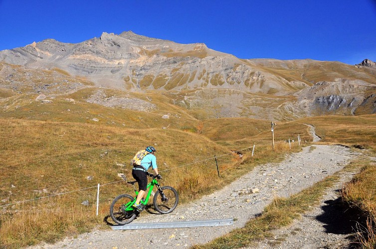
> From Les Clots, turn left onto a magnificent single track crossing the slate scree (take care as this is an exposed section). Carry on along the mountainside
until you reach the ski runs of Le Chazelet, before gradually losing height until you reach the snack bar at Le Chazelet ski resort. Ride up 50 m to the bottom
of the ski lift and then return to the village on the track that goes off to the right.
> Ride through Le Chazelet and go back to La Grave by the GR 54 path via Les Terrasses.
Technical informations
30 km
|
max. 2071 m
min. 1424 m
1109 m
1109 m
| |||
Style : Mountain Public : SportsmenReserved for experts/confirmed | ||||
Altimetric profile
Starting point
Steps
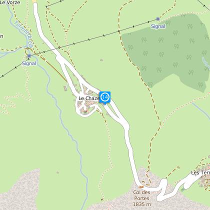
La Grave
From the Bureau des Guides in La Grave, ride down to the lower ski lift car park and take the path that goes down to the Romanche River.
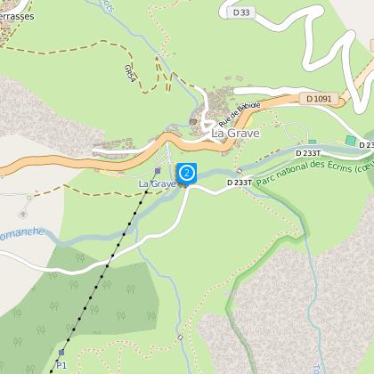
Cross the Romanche
Cross the bridge and turn left onto the tarmac “Route de l’Envers”. Follow the road.
Towards
Then turn left onto the “Sentier des Vallois” path towards Villar d’Arène (this path starts before the road crosses the river again). Ride/push until the path comes out at the Tunnel des Ardoisières.
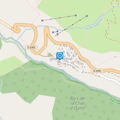
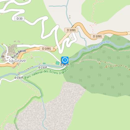
Villar d'Arène
From the village square, ride up the right-hand street (wrong way up the one-way street), that turns into a path a few hundred metres further on (the tarmac road goes off to the left). This leads to the narrow “Route du Pied du Col”.
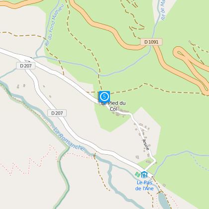
Le Pied du Col
Once in the hamlet, turn left towards Les Cours (the path crosses the main road after 2 km).
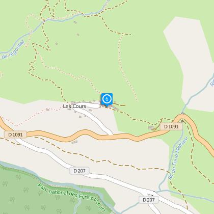
Les Cours
At the fountain in Les Cours, turn right and then left 100 m further on towards the Lac du Pontet (track for 1 km, road for a further 2.5 km and then a steep path).
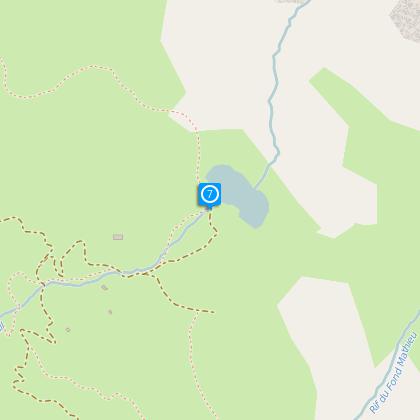
Lac du Pontet
Ride around the lake on the left-hand side (past the snack bar) and take another steep path which turns into a magnificent single track that joins the Col de l’Aiguillon.
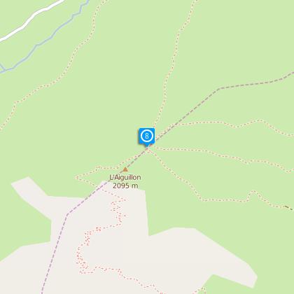
Col de l'Aiguillon
This marks the start of a fine downhill section to Valfroide.
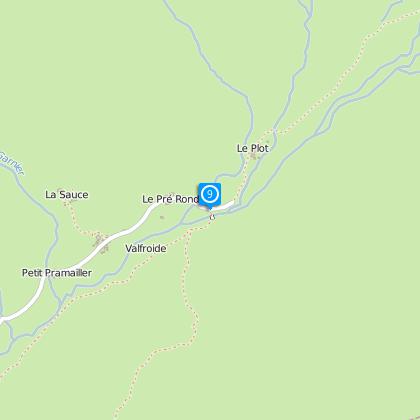
Valfroide
From Valfroide, follow the track and then the road to Le Ventelon (passing through Les Hières).
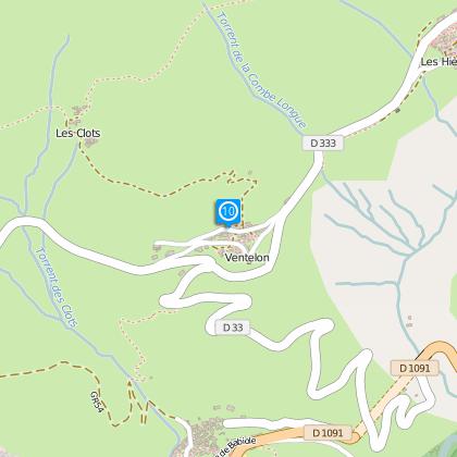
Ventelon
Once in Ventelon take the road most to the right for 400 m, followed by the track that turns off to the right and goes (steeply) up to the hamlet of Les Clots. Or join Le Chazelet by the tarmac road to shorten the route.
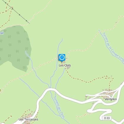
Les Clots
You then turn left onto a magnificent single track crossing the mountainside (take care on the slate of the exposed section).
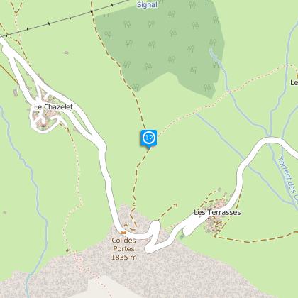
Take the track on the rignt
You then come to a track where you turn right to the ski runs of Le Chazelet.
Towards Le Chazelet
Ride up 50 m to the bottom of the ski lift and then return to the village on the track that goes off to the right.
Le Chazelet
Ride through Le Chazelet and then take the track down towards Notre Dame de Bon Repos / Les Fréaux.
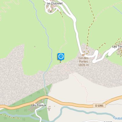
Notre Dame de Bon Repos
The track turns into a single track that becomes tricky from the chapel onwards (watch out for exposed sections).
Points of interest
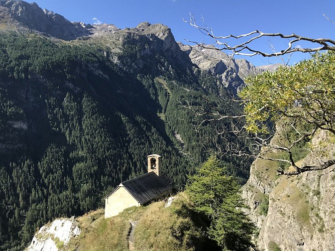
Bon Repos Chapel
The Chapel Notre-Dame de Bon Repos stands on a promontory along the path connecting the Chazelet village to Les Fréaux. Its date of construction is uncertain, but it probably dates back to the eighteenth century. It is a place of worship and memory.Passable in Summer only because the trail is steep.
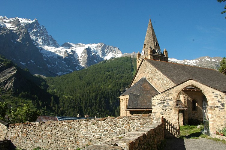
Notre-Dame de l’Assomption church
The church was built around the 11th century. It is the oldest monument in the area and has been a listed building since 1959. With the Pentitents Chapel it forms a beautiful architectural complex at the heart of the village of La Grave.The church built in the roman lombard style is placed under the protection of Our Lady of the Assumption. It is surrounded by a graveyard with beautiful wooden crosses that are typical of La Grave: the triangle represents the Holy Trinity and the circle represents the unity of the Father, the Son and the Holy Spirit. The cemetery is a temporary resting place. When the grave is removed, the heart-shaped brass plate that you see on each cross is placed on a wood panel on the wall of the church.
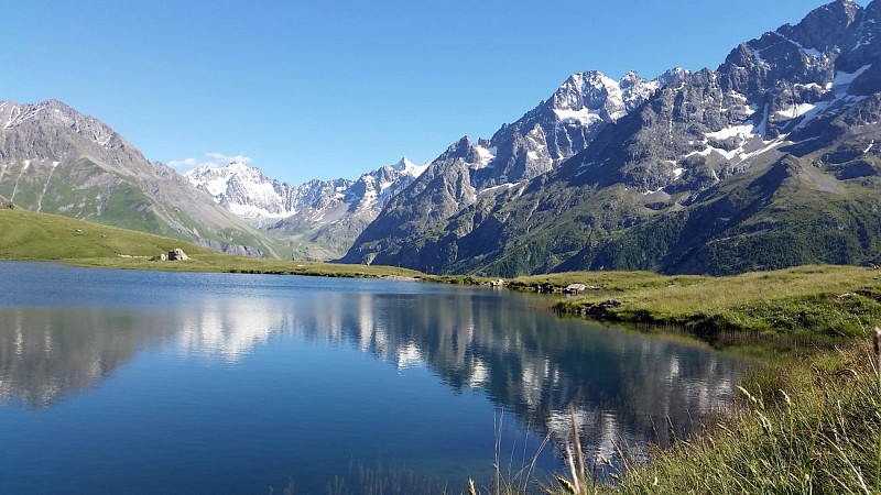
Le lac du Pontet
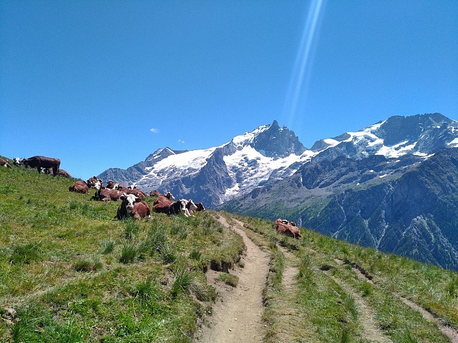
Beautiful lake above the hamlet of Les Cours, near Villar d'Arêne. You can get closer by car, but the walk starting from Les Cours hamlet, across the fields by the small road, is very beautiful and you may be able to see marmots. Fishing siteA 45 minutes walk from the hamlet of Les Cours, 20 minutes from the first parking and 15 minutes from the second parking Stunning views of the mountain Les Agneaux, the massive of La Meije and its glacier and the valley below Trailer snack to restore yourself by the water side
N°12 Romanche - Tour du Plateau d'Emparis
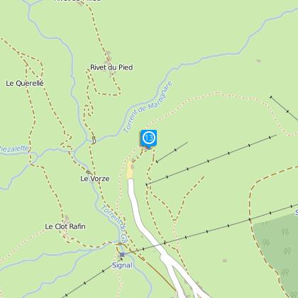
Boucle très sportive et techniqueAu départ du Chazelet, prendre la direction du vallon de la Buffe, traverser les villages des Rivets et suivre la piste rive gauche jusqu'au fond du vallon A la baraque de la Buffe, prendre à gauche, un sentier raide, qui nécessite, poussage et alternance de roulage pendant presque 1 heure. Une fois arrivé sur le plateau descendre le joli sentier qui s'offre à vous, traverser les prairies, puis rejoindre le col St-Georges. Suivre la piste pendant une centaine de mètres, puis couper à gauche, sur le GR qui descend. Monter en direction du col du Souchet, par le sentier. Au col du Souchet, prendre à droite, un sentier qui monte et fait le tour du lac Noir, et revient vers le lac Lérié Descente rapide par le très joli GR vers le sommet du téléski du plateau d'Emparis. Après avoir croisé le téléski, prendre à gauche une descente plus technique menant au Clot Raffin, puis rejoindre le Village du Chazelet par une dernière courte montée.
Date and time
- From 01/06/2024 to 31/10/2024
- From 01/06/2025 to 31/10/2025
Additional information
Updated by
Oisans Tourisme - 18/03/2024
www.oisans.com
Report a problem
Environments
Mountain location
Open period
From 01/06 to 31/10.
Contact
Phone : 04 76 79 90 05
Email : info@oisans.com
Website : www.bike-oisans.com
Location complements
As this is a circular route, you can start from either La Grave, Villar-d’Arène or Le Chazelet.
Topo guides and map references
Topo guides references :
Route in the "MTB in Oisans" guide (Oisans Tourisme)
Espace VTT-FFC La Grave - La Meije / Villar d'Arène
Map references :
IGN Top 25 Valloire 3435 ET and Meije Pelvoux 3436 ET.
Reception complements
X country :
The flagship MTB discipline and an Olympic sport since Atlanta in ‘96. Cross-country is traditionally enjoyed on terrain that is not too rough, on lighter bikes with fork suspension of between 100 and 130 mm and tyres of between 1.8 and 2 inches at the most. In Oisans, the steep terrain and significant height differences make this style less popular than its sister style, enduro. There are however some trails in the valleys that are accessible to everyone, as well as some that are slightly more challenging that we have classified as midway between X country and enduro.
Data author
