Alert
Alerts
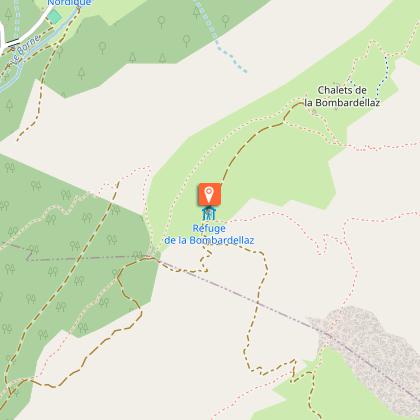
Lac de Tardevant, via Refuge de la Bombardellaz
Description
A beautiful hike to one of the few lakes in the Aravis chain, via the Refuge de La Bombardellaz. The combes of Pacally and Tardevant, the site's typical geology and the lake nestling in its bosky bower give the area a wild atmosphere.
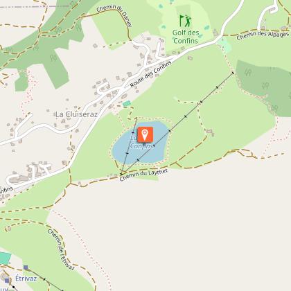
Starting from l’Arpettaz, just a short walk from Lake Confins, this route allows you to climb one of the most beautiful combes (valleys) in the Aravis range.
Throughout your hike, you can enjoy numerous viewpoints over the surrounding peaks. On this side of the Aravis, you are in an ideal spot to observe Mont Lachat du Grand-Bornand, with the Bargy Massif and Pic de Jallouvre forming a stunning backdrop.
As you make your way up toward Lake Tardevant, you will pass through a variety of landscapes, including alpine pastures, forests, rocky terrain, and grassy valleys.
At the end of this fairly demanding ascent, the lake reveals itself, nestled beneath the cliffs of the Rochers de Salla. Take time to observe the beautiful rock faces on either side, with their layered strata, vertical and overhanging folds, and visible faults.
Be sure to take a break at the Refuge de la Bombardellaz, which offers a lovely view over the Bouchet Valley.
Technical Information
Altimetric profile
Starting point
Points of interest
Date and time
- From 01/06/2026 to 30/09/2026
- From 01/06/2027 to 30/09/2027
Additional information
Open period
From 01/06 to 30/09 daily.
Please check with the Tourist Office beforehand for current access conditions.
Subject to favorable snow and weather conditions.
Updated by
Office de Tourisme de La Clusaz - 21/04/2026
www.laclusaz.com
Report a problem
Environments
Lakeside or by stretch of water
Mountain view
Panoramic view
Lake view
Mountain location
Contact
Phone : 04 50 32 65 00
Email : infos@laclusaz.com
Website : https://www.laclusaz.com
Type of land
Not suitable for strollers
Stone
Rock
Ground
Location complements
Parking: Arpettaz car park.
In high season, access is also possible by Aravisbus shuttle bus: Line 1 (Les Confins), stop “Confins Chapelle.”
Topo guides and map references
Topo guides references :
Hiking Guidebook TOURNETTE | BORNES | ARAVIS : "Randonnées Sportives et Incontournables" (available for purchase at the Tourist Office for €3, in French only).
Map references :
Route Map TOURNETTE | BORNES | ARAVIS (available for purchase at the Tourist Office for €5, only in French).
IGN Top 25 Map 3430 ET: La Clusaz – Le Grand-Bornand (available for purchase in bookshops or similar retail outlets).
Reception complements
Whatever hike you choose, remember to pack snacks, enough water, sunglasses, sunscreen, a small first-aid kit, as well as clothing suitable for your outing depending on the season and the weather forecast.
Animals
Yes. Dogs must be kept on a leash at all times. Er zijn kuddes aanwezig die bewaakt worden door beschermingshonden.
