Alert
Alerts
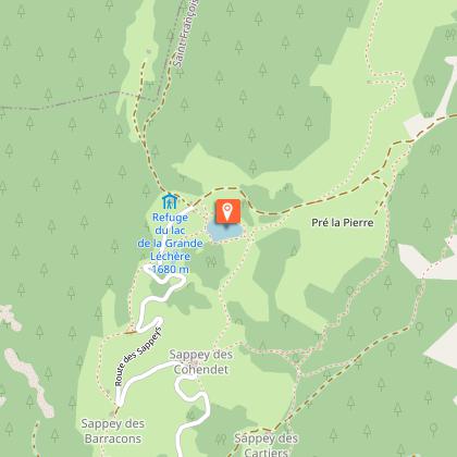
The "Grande Léchère" lake loop (3)
Description
[Montgellafrey area]
Red level (medium) itinerary. around 3h30 long.
Starting point from «le Mollard du Praz», after the Replat hamlet. Walk on the road and arrived at the first turn, take on the right on a forest track. Leave the main track that goes on the right and go straight ahead. Then, you will cross a narrow passage with a cable on the wall to hang yourself on. At the mangette, the path goes up on the right. At the intersection of the «Cohendets», let «les Sapeys des Cohendets» on your left. After you have passed the «Lac de la Grande Léchère», take the track passing next to the municipal water tank until you reach the «Croé pas». Take the path that goes down on the right. At the «Forêt des Vernettes», take the track turning on the right and then immediately on the left (hairpin bend). At the «Forêt du Praz», take on the right and then right away on the left. The pist goes down to the Mollard du Praz, where you began your hike.
Technical Information
Altimetric profile
Starting point
Points of interest
Date and time
- From 01/07/2026 to 31/08/2026
- From 01/07/2027 to 31/08/2027
Additional information
Updated by
Office de Tourisme de Saint François Longchamp - 24/04/2026
saintfrancoislongchamp.com
Report a problem
Environments
Lakeside or by stretch of water
Mountain view
Waterside
Lake view
Mountain location
Open period
From 01/07 to 31/08 : open daily.
Contact
Phone : 04 79 59 10 56
Topo guides and map references
Topo guides references :
Hiking guide edited by the Tourist Office of Saint-François Longchamp.
Location complements
Highway access: A43; exit n°26 "La Chambre" (careful, in Winter the GPS indicates to take the Col de la Madeleine from Albertville and from La Chambre, to cross the Montgellafrey village. But the Col de la Madeleine and the road of Montgellafrey are closed in winter). In winter and in case of snow, winter equipments are mandatory.
Railway access: Saint-Avre/ La Chambre station. Schuttle between the station and the resort.
Airport access: Lyon, Chambéry, Grenoble, Genève.
During the summer, possibility to park nearby.
Animals
Yes. Dogs allowed. They must be kept on leash.
