Alert
Alerts
Type of practice
Walking
Easy
3h
Cycling
Easy
Mountainbiking
Easy
Presentation
Map
Points of interest
Cirkwi brief's
Ratings and reviews
See around
From Viarmes to Presles

Credit : Cyril Badet pour le PNROPF
The Cirkwi brief
Discover the Enchanting Trail from Viarmes to Presles
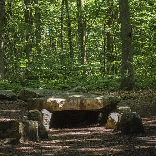
Crafted by the Regional Natural Parks of Ile-de-France, this itinerary offers a journey through the serene landscapes stretching from Viarmes to Presles. Without diving into the granular details, let's traverse the essence of this trail—starting from a decline near a station, winding through quaint streets, and culminating in a mesmerizing walk by a small lake and a prominent dolmen. This path is not just a trek but a narrative that guides you through forestry wonders, historical artifacts, and the calmness of village life. It epitomizes the perfect blend of nature’s artwork and cultural heritage, making it a must-trek path for enthusiasts craving a scenic adventure.
Technical Insights: Trail Overview
Spanning a distance of 10.334 km, this trek unveils a topographical variety, with elevations ranging from 50 meters at the lowest to 211 meters at the highest points. The trail boasts an altitude variance, entailing an approximate positive elevation change between 225 to 292 meters which provides a moderate challenge suitable for most hikers. Endorsed by the Regional Natural Parks of Ile-de-France, the route is carefully crafted, ensuring a blend of scenic vistas and natural landmarks. Its composition and elevation offer a comprehensive yet enjoyable hiking experience, underscored by its meticulously planned path.
Seasonal Tips & Safety Recommendations
Embracing this scenic journey from Viarmes to Presles requires more than just enthusiasm. Regardless of the season, ensure you're equipped with sturdy walking shoes to navigate the diverse terrains. Spring showers bring lush landscapes but also slippery paths; caution is advised. Summer offers vibrant foliage, yet hydration is key under the sun’s embrace. Autumn’s cool breeze and colorful tapestry make it an ideal time, though layers are essential as temperatures can dip. Winter, cloaked in serene silence, demands warm attire and an early start to seize daylight. Safety is paramount - always inform someone of your travel plans and pack essentials including water, snacks, and a first-aid kit.
Historical Chronicles of Viarmes to Presles
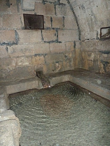
The trek from Viarmes to Presles threads through a region rich in history and culture. Viarmes, rooted in a geological marvel, and adjacent to the Forest of Carnelle, offers a glimpse into nature's profound beauty and the ingenuity of medieval engineering with the Fontaine aux Moines. This area, nurtured by the Royal Abbey of Royaumont's monks, still houses an operational water supply network from the 13th century. The walk encapsulates a journey through time, not just terrain, embodying a legacy that encompasses the dolmen's ancient mystery and the vitality of local villages, reflecting the enduring spirit of France’s heartland.
Climate Insights: Best Time to Visit
The region experiences a temperate climate, essentially marked by mild winters and warm summers. The distinct seasons each offer unique charms for adventurers. Spring, with its explosion of flora and temperate weather, presents the ideal conditions for hiking. Summer, although warmer, awakens the trail’s vibrancy, requiring sun protection for comfortable travel. Autumn is arguably the most picturesque, with moderate temperatures and a kaleidoscope of colors. Winter, though cooler, can still be appealing for well-prepared hikers seeking tranquility away from the bustling tourist seasons. For optimal experience, spring through autumn is recommended, leveraging the mild climate for outdoor exploration.
Crafted by the Regional Natural Parks of Ile-de-France, this itinerary offers a journey through the serene landscapes stretching from Viarmes to Presles. Without diving into the granular details, let's traverse the essence of this trail—starting from a decline near a station, winding through quaint streets, and culminating in a mesmerizing walk by a small lake and a prominent dolmen. This path is not just a trek but a narrative that guides you through forestry wonders, historical artifacts, and the calmness of village life. It epitomizes the perfect blend of nature’s artwork and cultural heritage, making it a must-trek path for enthusiasts craving a scenic adventure.
Technical Insights: Trail Overview
Spanning a distance of 10.334 km, this trek unveils a topographical variety, with elevations ranging from 50 meters at the lowest to 211 meters at the highest points. The trail boasts an altitude variance, entailing an approximate positive elevation change between 225 to 292 meters which provides a moderate challenge suitable for most hikers. Endorsed by the Regional Natural Parks of Ile-de-France, the route is carefully crafted, ensuring a blend of scenic vistas and natural landmarks. Its composition and elevation offer a comprehensive yet enjoyable hiking experience, underscored by its meticulously planned path.
Seasonal Tips & Safety Recommendations
Embracing this scenic journey from Viarmes to Presles requires more than just enthusiasm. Regardless of the season, ensure you're equipped with sturdy walking shoes to navigate the diverse terrains. Spring showers bring lush landscapes but also slippery paths; caution is advised. Summer offers vibrant foliage, yet hydration is key under the sun’s embrace. Autumn’s cool breeze and colorful tapestry make it an ideal time, though layers are essential as temperatures can dip. Winter, cloaked in serene silence, demands warm attire and an early start to seize daylight. Safety is paramount - always inform someone of your travel plans and pack essentials including water, snacks, and a first-aid kit.
Historical Chronicles of Viarmes to Presles
The trek from Viarmes to Presles threads through a region rich in history and culture. Viarmes, rooted in a geological marvel, and adjacent to the Forest of Carnelle, offers a glimpse into nature's profound beauty and the ingenuity of medieval engineering with the Fontaine aux Moines. This area, nurtured by the Royal Abbey of Royaumont's monks, still houses an operational water supply network from the 13th century. The walk encapsulates a journey through time, not just terrain, embodying a legacy that encompasses the dolmen's ancient mystery and the vitality of local villages, reflecting the enduring spirit of France’s heartland.
Climate Insights: Best Time to Visit
The region experiences a temperate climate, essentially marked by mild winters and warm summers. The distinct seasons each offer unique charms for adventurers. Spring, with its explosion of flora and temperate weather, presents the ideal conditions for hiking. Summer, although warmer, awakens the trail’s vibrancy, requiring sun protection for comfortable travel. Autumn is arguably the most picturesque, with moderate temperatures and a kaleidoscope of colors. Winter, though cooler, can still be appealing for well-prepared hikers seeking tranquility away from the bustling tourist seasons. For optimal experience, spring through autumn is recommended, leveraging the mild climate for outdoor exploration.
Automatically generated.
Technical Information
Walking
Difficulty
Easy
Duration
3h
Dist.
10 km
Type of practice
Walking
Easy
3h
Cycling
Easy
Mountainbiking
Easy
Show more
Altimetric profile
Starting point
Lat : 49.1171126214Lng : 2.36829595622
Points of interest
Data author

proposed by
Parcs naturels régionaux d'Ile de France
48 Rue d'Hérivaux 60560 ORRY LA VILLE France
Ratings and reviews
To see around