Alert
Alerts
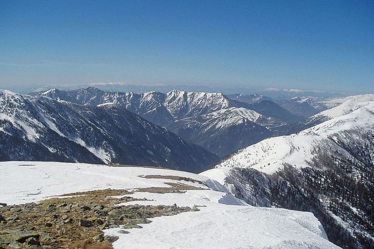
The panoramic view from Caïre Gros
IGN cards


Description
A bucolic through the various stages of vegetation, all the way up to the summit (2087m). This path heads through former farming terraces which now lie fallow, a pine forest, meadows interspersed with groves of trees, a forest of fir trees and calcareous grassland.
From Saint-Dalmas, the itinerary almost entirely follows GR5, which is signalled by a red and white double mark. The departure point is from the square located beneath the church (marker 78). Turn right in the village, continue for 60m until you reach marker 76. Turn left onto the track towards Col de la Madeleine.At marker 75, continue straight on, head through the pine forest and past the first larch trees. The path is quite steep until you reach the Col du Varaire, which will take approximately an hour.Go past a small spring and some old wooden drinking troughs. At marker 310 (Col du Varaire), follow the line of the ridge between La Vésubie and Le Valdeblore; Le Caïre Gros can be seen from here.Head through the larch trees which are home to several different species of bird. The woods become denser with darker trees: spruces and firs. Continue on the left to reach the Col des Deux Caïres (marker 99). The mouth of the Var can be seen from here.Now leave GR5 and, on the left of the col, take the narrow footpath which rises in zigzags towards the summit (30 minutes approximately). When you reach it, the full panorama becomes will be revealed.Follow the same route for the return journey, although a variation is possible, extending the hike by heading back via the Col de la Madeleine from the Col des Deux Caïres.This detour will take an extra hour. Follow the Conseil Départemental markers to get back to Saint-Dalmas.
Technical Information
Altimetric profile
Starting point
Points of interest


Additional information
Departure
Saint Dalmas, square
Arrival
Saint Dalmas, square
Ambiance
Caïre Gros connects the valleys of La Vésubie and La Tinée. From its summit, which touches the Mercantour, a view which extends all the way from the Mediterranean to the high mountains opens up.
Access
Via La Vésubie: from Nice, take the A8 motorway – Exit 52 Nice Saint Isidore - then RD6202 (Route de Grenoble) until you reach Plan du Var, then D2565 towards Saint Martin Vésubie.
Via La Tinée: from Nice take the A8 motorway – Exit 52 Nice Saint Isidore - then RD6202 (Route de Grenoble) to La Mescla, then D2205 (Vallée de la Tinée). Go through La Bollinette, take the D2205 towards Valdeblore - La Colmiane.
Advised parking
Village square
Public transport
Arriving by bus: Number 730 Nice (Vauban) - Saint Martin Vésubie
Number 746 La Bolline - La Colmiane (connections for Saint Dalmas)
Transport upon request:
Randobus service from July to September (upon reservation) and daily service from July to August.
Consulter timetables on the Ligne d'Azur website.
Data author
