Alert
Alerts
Lac du Lauzanier


Description
The proposed itinerary has been specifically adapted and awarded tourism and handicap status over the first 500 metres for wheelchair access. Off road “Joëlette” wheelchairs are available for free hire at Larche Tourism Office.
There are Mercantour National Park information signs at the carpark, follow GR5 (white and red markers) heading up the valley.
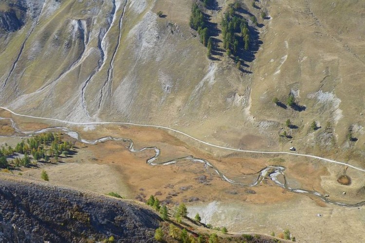
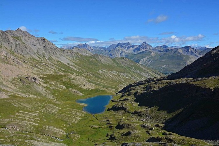
The first 500 metres are fully accessible for people in wheelchairs with no need for assistance and a multi-sensory information has been specially designed for visually impaired and hearing-impaired people (PNF/GMF sponsorship). The track heads gently upwards on the left bank of the Ubayette river which winds through a wetland area before passing close to sheepfolds at Eyssalps where you may be lucky enough to meet the shepherd and his sheep in the mountain pasture. As the track begins to rise, the waterfalls coming down from Enclausette and the Lac du Lauzanier can be seen on the left. Keep climbing until you reach the lake which reflects the summits which tower over it.
All along the path, you will easily be able to watch marmots. In the interests of their survival, please do not feed them and please respect the “quiet zones” which have been set in order to allow the marmots to live their lives in peace.
Hikers with energy to spare can continue the walk by walking around the right-hand side of the lake on path GR5-GR56, in much more mineral-based surroundings; this will lead them to the Pas de la Cavale (2671m) beneath the Trois Évêques peaks.
Follow the same route on the return journey.
We would like to remind you that because this path is entirely situated in the heart of the Mercantour National Park, no dogs are allowed, even if they are on a lead.
Technical Information
Altimetric profile
Starting point
Points of interest
Additional information
Departure
Pont Rouge carpark, 5 km after Larche
Arrival
Lac du Lauzanier
Ambiance
The Lauzanier valley was created by an immense glacier several thousand years ago. In the last century, hay fields extended over this area. The agricultural and pastoral use this land was put to has resulted in the presence of a wide diversity of flowering plants, including the emblematic “Queen of the Alps” (Eyringium alpinum).
Access
Larche, 25km from Barcelonnette.
Accessibility infrastructure
Free rental of "Joëlette" off-road wheelchairs and of the "handi-ecoguide" for the blind.Larche Tourism OfficeTel. : +33 4 92 84 33 58www.ubaye.com
Mercantour National Park at BarcelonnetteTel. : +33 4 92 81 21 31mercantour-parcnational.fr
Advised parking
Pont Rouge carpark. In summer, a bus leaves from the hamlet of Malboisset.
Public transport
Local bus lines in Alpes-de-Haute Provence. Regular/weekly lines Digne-les-Bains, Barcelonnette, Larche. Departmental Council Transport ServiceTel.: 33 (0)4 92 30 08 00www.cg04.fr
Advice
Pleasant and accessible, the Lauzanier valley is highly popular in summer. If you wish to avoid the crowd, it is best to set off early in the morning.
Is in the midst of the park
The national park is an unrestricted natural area but subjected to regulations which must be known by all visitors.
Data author
