Hiking around Achard lake
Description
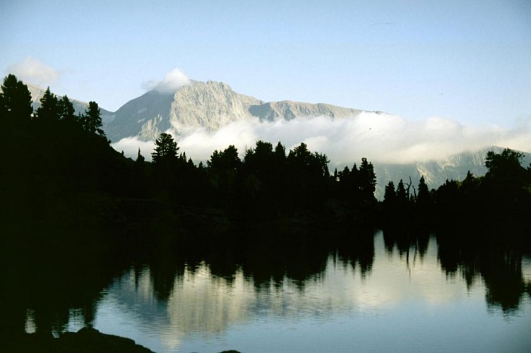
This small lake is located in an exceptional natural setting. It is an ideal destination for a family outing, with children. The path stays interesting with its berries, pine trees and a magnificent view of the Taillefer.
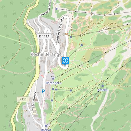
From Saint-Martin-d'Uriage take the road towards Chamrousse (D111), pass Chamrousse 1650 - Recoin and park at Chamrousse 1750 - Roche Béranger in the "La Croisette" parking lot. From the "La Croisette" parking lot, take the narrow road up to Chalet le Malamute, until you come to a wide bend to the left where a track branches off. Follow this path to the right, towards the lake.
Initially gently sloping, the rocky path alternates between gentle ascents and descents, with easy sections over rocky slabs. Leaving the path leading up from the Arselle meadow to the right, you finally reach the grassy plateau of Lac Achard (1917m). The numerous boulders and small streams scattered across the plateau are a great playground for children.
⚠ Please note: the Espace Naturel Sensible (ENS) "Tourbière de l'Arselle et lac Achard" is a protected area (classified APPB - Arrêtés Préfectoraux de Protection Biotope), so there are a few rules to observe to help protect it. Swimming, lighting fires, camping, gathering and dumping garbage are strictly forbidden, as is bivouacking during the peak season between early May and late October. Please stay on the trails.
☆ The little extra: the "hiking star" summer medal for children!
On presentation of a photo taken at the hiking site, brave little hikers will be awarded a named diploma + possible purchase of the "lac Achard" silver star to hang proudly on the backpack (on sale for €2.50 at Tourist Offices).
Technical informations
7.5 km
|
max. 2247 m
min. 1778 m
217 m
| |||
Accessibility | ||||
Public : Family | ||||
Altimetric profile
Starting point
Additional information
Updated by
Isère Attractivité - 10/04/2024
www.alpes-isere.com
Report a problem
Environments
Close to a public transportation
Mountain location
Panoramic view
Bus stop Lake view
Mountain view
Open period
All year round.
Subject to favorable weather.
Contact
Phone : 04 76 89 92 65
Email : info@chamrousse.com
Website : www.chamrousse.com
Location complements
Resort road access from Grenoble: Rocade Sud > exit no. 2 "Uriage" > Route départementale 111 (RD 111) on the Luitel or Seiglières side.
Recommended parking: Parking Croisette (P4), 623 route de la Croisette (100 m and about 2 minutes' walk from resort center).
Public transport - Chamrousse 1750 - Roche Béranger stop:
- regional bus line T87 (to/from Grenoble), "Chamrousse 1750" stop
- seasonal bus lines :
- [winter] Transaltitude (to/from Grenoble), stop "CHAMROUSSE 1750 Roche Béranger" and Skibus 707 (to/from Uriage), stop "CHAMROUSSE ROCHE BERANGER".
- summer] Estibus 707 (to/from Grenoble), "CHAMROUSSE ROCHE BERANGER" stop.
- resort shuttle: "Centre Commercial (1750)" stop (to/from Chamrousse 1650 - Recoin and Chamrousse 1600 - plateau de l'Arselle/nordic area).
- transport on demand (TAD) TouGo - line G701 to/from Uriage
Further information at www.itinisere.fr
Topo guides and map references
Topo guides references :
"Belledonne and Chartreuse in Grésivaudan" guidebook
Map references :
IGN "3335OT - GRENOBLE" map
Reception complements
Animals allowed: dogs on leash are allowed on all trails.
The shepherd who works in Chamrousse in summer does not have a guard dog (patou).
