This loop between Oisans and Savoy will take you over the Col du Glandon and the Col de la Croix de Fer. Cyclists who tackle these legendary passes exchange greetings. They share the same sense of achievement: it’s tough, it’s long, but it’s so beautiful!
Itinerary no. 15 of the “Cycling in Oisans” guide (Oisans Tourisme)
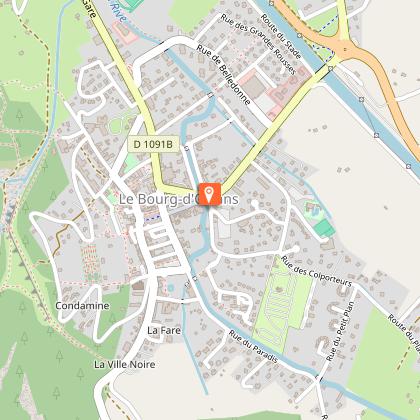
Departure / Arrival (loop): Bourg d’Oisans 720 m
Time: 7 h 30
Distance: 150 km
Highest point: 2071 m
Lowest point: 463 m
Total ascent: 3820 m
Max. gradient: 13%
Map: Michelin Local Map no. 333 Isère, Savoie
ITINERARY
From Bourg d’Oisans follow the D1091 towards Grenoble.
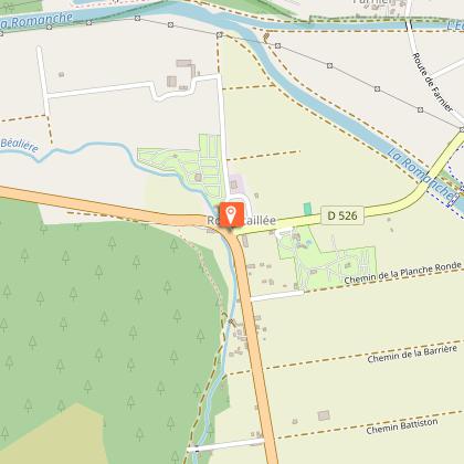
In Rochetaillée continue towards “Allemond / Col du Glandon - Col de la Croix de Fer”.
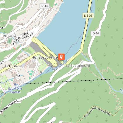
On leaving Allemond, climb up 2 hairpin bends to get to the top of the Verney dam. At the end of the dam, the route towards “Col du Glandon - Col de la Croix de Fer” will be signposted, taking you alongside the Lake Verney.
At the end of the lake, you will start a steep climb up to Rivier d'Allemond.
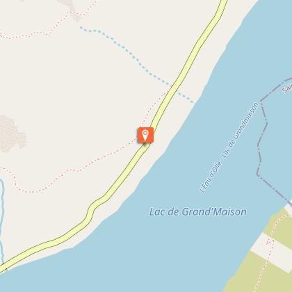
At Rivier, you can take a little breather before dropping down to the bottom of the valley and then attacking a new strenuous climb up to the Lake Grand Maison.
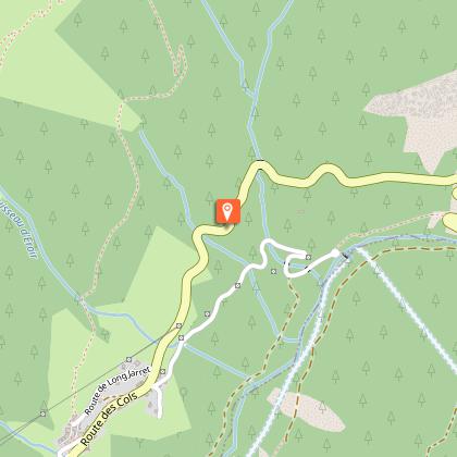
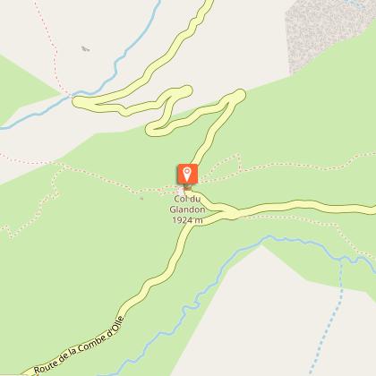
Once arrived at the lake, the steep-sided valley gives way to beautiful alpine pastures. The ride will be more easy-going from here to the Col de Glandon (1924 m).
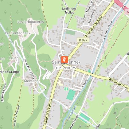
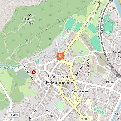
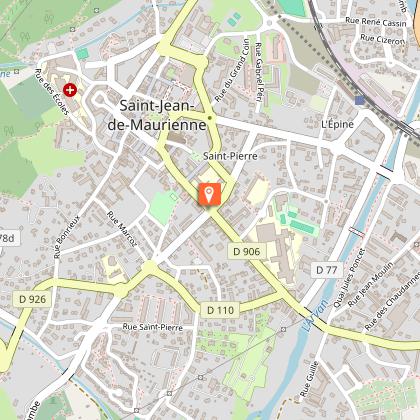
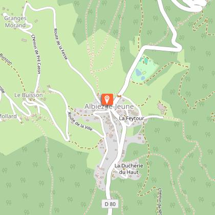
Once over the pass, continue along the D927 to Saint-Étienne-de-Cuines. Once you reached the village centre, fork to the D74 towards Sainte-Marie-de-Cuines. Pass under the motorway and take a right turn onto D1006 towards Saint-Jean-de-Maurienne. At the first roundabout, follow the D906 with the signposting “Saint Jean de Maurienne / Col de la Croix de Fer”. Cross Saint-Jean-de-Maurienne in the direction of “Vallée de l'Arvan”. To reach Albiez-le-Jeune, follow the signposts to “Torino / St-Michel-de-Maurienne”, then, once in an industrial estate, you will find the direction “Albiez-le-Jeune” (D81).
Climb the D80 up to Albiez-le-Jeune, go past Albiez-le-Vieux and the Col du Mollard (1638 m) up to the road D926 that you will follow as far as the Col de la Croix de Fer.
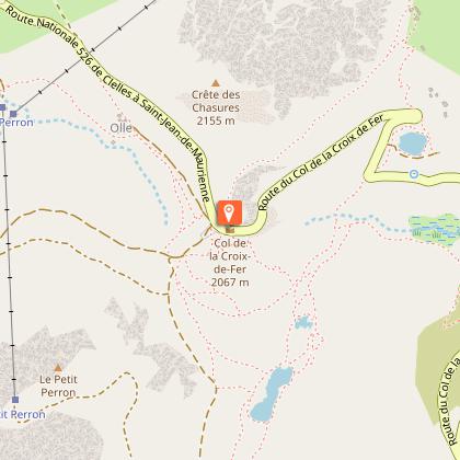
When you reach the Col de la Croix de Fer (2067 m), you are at the highest point of your route. All you have to do now is let yourself wheel it down to Bourg d'Oisans following the route to “Col du Glandon” and then “Allemond”. You will find yourself back on the route you took on the way out.
POSSIBLE ALTERNATIVE: Via Arvan Valley
From Saint Jean de Maurienne keep going towards “Centre ville / Vallée de l'Arvan”. At the roundabout decorated with a giant Opinel knife, follow the D926 towards “col de la Croix de Fer”. This route is 10 kilometres shorter than the D80 leading up to the Col du Mollard. However, due to the tunnels and frequent road works, it may be more tiresome.
---
Distance: 15 km
Time: 2 h
Total ascent: 922 m
150 km
|
max. 2065 m
min. 462 m
3820 m
3820 m
| |||
Accessibility | ||||
Styles : MountainCompetition Public : SportsmenCyclistsReserved for experts/confirmed |
From Bourg d’Oisans follow the RD1091 towards Grenoble. When you get to Rochetaillée, follow the D526 to Allemont.
Prendre direction "Allemont / Col du Glandon / Col de la Croix de Fer"
From Allemont, ride along the dam and cycle towards Le Rivier d’Allemont - Grand Maison.
From Le Rivier four hairpin bends will take you back down to the stream of l’Eau d’Olle. From its banks you will have a regular but strenuous climb up to the Grand Maison barrage.
Once near the dam slope softens, you will find your rhythm all the way up to the pass.
Turn left onto the D927 to reach the Col du Glandon. Then join St-Colomban-des-Villards.
From Sainte-Marie-de-Cuines join Saint Jean de Maurienne by D74.
Then follow the D80 towards the Col du Mollard - Saint Sorlin. You go through Albiez-le-Jeune.
Pour aller sur Albiez-le-jeune suivre les indications "Torino / St-Michel-de-Maurienne"
Suivre la direction "Albiez-le-Jeune" par la D81 puis la D80
Still on the D80 cycle through Albiez-le-Vieux, cycling near the col du Mollard and join the D926.
Join Saint-Sorlin-d'Arves.
Cycle down on the same road to reach Bourg d'Oisans.
Here you are in Bourg-d'Oisans at an altitude of 700m: all around you are mountains and underfoot is the plain. This landscape has been shaped over thousands of years at the same time as the Alps were being created.The mountains you see, and the plain you walk on, are the consequences of shifting continents, the major ice ages and the subsequent warming. Humans have also helped shape this landscape over the last few centuries, adapting to and taking advantage of natural and geological constraints. The dammed rivers and the network of drainage canals, for example, have allowed the habitat to expand and agriculture to develop in the plain, creating a mountain "bocage" with fields and hedges. However, these actions have never eradicated certain natural hazards, such as avalanches and rockfalls. Half-wild and half-tamed, this landscape and its features are home to a multitude of animal and plant species, some of which are protected. Lake St Laurent: when the Vénéon-Romanche glacier retreated, it stagnated in the lower valley and a lake of more than 5,000 hectares then occupied the entire valley from Bourg-d'Oisans to Allemond. The alluvium deposited by the Romanche and the Vénéon gradually plugged up the lake and filled in the plain to a depth of 500m. In fact, if it weren't for the lake, which gradually filled in, the village would only be at an altitude of 200m! Bourg-d'Oisans is now a delightful little town of international renown where mountain lovers come, both in summer and winter, to stay and enjoy the many activities on offer!
The history of Allemond has been marked by the mining industry and Alpine agriculture. Vieux Allemond, around the church and along the road leading to the Mairie, still has the traditional characteristics of Oisans villages.Allemond was known for its mining under Louis XIII and XIV, housing royal foundries (behind the tourist office), in which minerals mined around the village, mainly silver, lead and copper, were melted. For many years, the Hotel des Tilleuls (now closed) occupied some of the buildings of the former royal foundry. This hotel, featuring a superb walnut staircase, was bought in the 1920s by a former mayor of the village. His two daughters, Raymonde and Margarete, were well-known local characters who ran the hotel for many years. It was even rumoured that Napoleon III stayed there. Until the 1960s and 1970s, people lived very simple lives, nearly all as farmers. Then at the end of the 1970s, the Grand-Maison dam project was launched, providing a huge economic boost for the village and the region as a whole. The project lasted 10 years and brought many thousands of workers to the area. These days, the village lives mainly from tourism, both in summer and winter.
Rochetaillée lierally means "cut rock" in French and looking up at the road carved out of the cliff face, it is clear how the village got its name. However, the exact origin of this road appears lost in the folds of history.Is this road, as many people believe, the remains of a Roman road, the indelible mark of an unstoppable sovereign population? Or, as Doctor Roussillon suggests in his Traveller's guide to Oisans, is it "the still visible trace of a path created during the existence of the lake, along the bottom of the neighbouring mountain and behind the small hamlet of Rochetaillée, from which it draws its name. Such were the circumstances in which this path was built." An observor at the end of the 19th century reported certain similarities beween the Porte des Bons and the Rochetaillée road, suggesting a close correlation between the two. Marks and tracks on the ground were reported to be similar and of exact equal width. Unfortunately, no trace of these marks has been found since and the campaign to clear and clean the site carried out by in 2004 by "Customs and Traditions of Oisans" also failed to uncover any evidence. To better understand this, it needs to be remembered that in the last century, the plain through which the road passes was like a desert without any vegetation. Both the cliff and the plain were completely bare, meaning that it was no doubt easy at the time for witnesses to observe and note the smallest details. These days, the road is virtually covered by vegetation and in some places, you can almost walk past without noticing it. But why carve the road out of the rock? If we go along with Docteur Roussillon's theory, the creation of Saint-Laurent lake would be the only tangible reason for this project, which must have involved considerable manpower and resources. The other theory, if we consider this to be a Roman road, suggests that any rapid progress towards the high mountain passes was hindered by the neighbouring plain. Perhaps it was a swamp or a lake that was liable to flooding due to the unpredictable behaviour of the Romanche river? The size of the project to build the road would also prove the importance of the "Oisans way" in the eyes of the Romans. Along the entire length of the platform, rectangular markings are carved out of the stone at regular intervals. These suggest that a structure consisting of beams and a wooden floor covered the road, widening it from 2 metres to 3 or 4 metres and making for easier progression. At suitable points, wider platforms were installed, known as "garages" that served as passing places for animals and carts. To this day, the track linking Rochetaillée to Bourg d'Oisans, via the hamlets of La Paute and Les Sables, is known as the "Chemin Romain". Source: Freneyd'Oisans.com/Mr Albertino
Mountain location
Oisans Tourisme - 08/04/2024
www.oisans.com
Report a problem
From 05/01 to 10/31 : open daily.
Learn about the opening date of paths.
Phone : 04 76 80 03 25
Email : info@oisans.com
Website : www.bike-oisans.com
Topo guides references :
Itinerary no. 15 of the “Cycling in Oisans” guide (Oisans Tourisme)
Map references :
Michelin Local Map no. 333 Isère, Savoie