Alert
Alerts
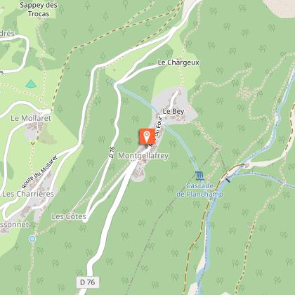
From Montgellafrey to the Covatières (2)
Description
[Montgellafrey area] 2 Km blue level path (easy) with a positive elevation of 117m and a negative elevation of 257m.
Starting point at the parking lot at the entrance of Montgellafrey, take the main road of the village to the bread oven. After the oven, you arrive at an intersection. Take the road on the right (and not the one going up with a no-entry sign) to the last houses and continue on this path. You meet a wooden sign «Montgellafrey- Le Bey». Go down towards the Bugeon stream. You arrive at an intersection; let the track going down straight on and take the one going slightly up on the left. Cross the stream and go up the other side to the Covatières.
Technical Information
Altimetric profile
Starting point
Points of interest

Date and time
- From 01/07/2026 to 31/08/2026
- From 01/07/2027 to 31/08/2027
Additional information
Environments
Mountain view
Mountain location
Updated by
Office de Tourisme de Saint François Longchamp - 24/04/2026
saintfrancoislongchamp.com
Report a problem
Open period
From 01/07 to 31/08.
Contact
Phone : 04 79 59 10 56
Topo guides and map references
Topo guides references :
Hinking guide, summer 2016, edited by the Tourist Office of Saint-François Longchamp.
Animals
Yes. dogs kept on leash are allowed.
