Alert
Alerts
Hiking itinerary: Tour des Dents Blanches GR®P mini 4 days on foot
Description
The tour of the Dents Blanches is a challenging route in the wilderness, suitable for expert walkers who know how to find their bearings in the mountains: several of the technical sections are more like high-mountain hiking.
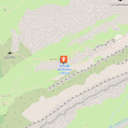
Day 1: Allamands (Samoëns) to Refuge Bostan-Tornay
The route winds its way up through forests and alpine pastures, between the Dents d'Oddaz and the Avouille, to the plain of the Bostan-Tornay hut, with its panoramic views over the Giffre valley, the Pointe de la Golèse and the Chalets de Bottière. An extraordinary site of rock, meadows and alpine flora.
Don't forget to climb to the Col de Golèse above the refuge, a 30-minute walk away. The view of the Terre Maudites, the Golèse refuge and the Giffre and Morzine valleys is breathtaking.
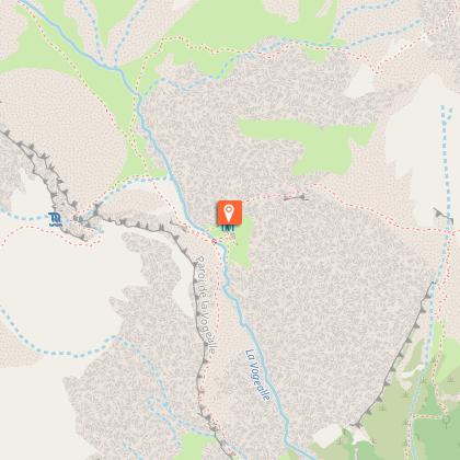
Day 2: Refuge de Bostan-Tornay to Refuge Vogealle from Col de Bostan.
You'll pass through a mining landscape with magnificent high-mountain panoramas: Lac des Verdets, Cirque du Bout du Monde, Pointe Rousse, Lac de la Vogealle, Dents Blanches, Pointe de Bostan.
Day 3: Refuge Vogealle to Refuge de Folly
Magnificent scenery, rocks of changing colors, from gray to anthracite, and once again the turquoise-blue waters of an alpine lake.
We propose a route on the French slopes, but if you wish, the itinerary can also be extended into Switzerland.
Technical Information
Altimetric profile
Starting point
Points of interest


Date and time
- From 01/06/2026 to 30/09/2026
- From 01/06/2027 to 30/09/2027
Additional information
Open period
From 01/06 to 30/09 daily.
Ask the wardens about the opening and closing dates of their huts on your route, and about current access conditions. Don't forget to book your accommodation in advance.
Subject to favorable snow and weather conditions.
Updated by
Conseil Départemental de la Haute-Savoie - 07/04/2026
hautesavoiemontblanc-tourisme.com/
Report a problem
Environments
Lakeside or by stretch of water
Mountain view
Panoramic view
Waterside
Lake view
Mountain location
Contact
Phone : 04 50 34 40 28
Email : infos@samoens.com
Website : http://www.samoens.com
Facebook : http://www.facebook.com/samoensofficiel
Type of land
Stone
Ground
Not suitable for strollers
Topo guides and map references
Map references :
Top 25 IGN n°3530ET - SAMOËNS
Location complements
Access (by car): From Cluses, take the D902 towards Taninges. Drive through Taninges. On leaving Taninges, take the D 907 via Samoëns, then head up towards the hamlet of Les Allamands. Three parking lots are available (Le Pied du Crêt, Les Allamands and Le Plans aux Arches).
Access (summer shuttle) : The starting point is accessible by shuttle bus during the summer from Samoëns (Line 8) .
Tricky passages
Depending on weather conditions, some sections may be tricky. In particular, this route should be avoided at the very start of the season, as persistent snow could make your progress perilous.
Guidebook with maps/step-by-step
1/ DAY 1: Les Allamands -Samoëns ( 1096m) to refuge de Bostan-Tornay (1757m) 2h30
2/ DAY 2: refuge de Bostan-Tornay (1757m) - refuge de la Vogealle (1901m) via the Col de Bostan.
Refuge de Bostan (1757m) - Col de Bostan (2290m): 1h40
Col de Bostant - Lac de la Vogealle (2001m): 3h15
Lac de la Vogealle- Refuge de la Vogealle (1901m): 0h15
3/ DAY 3: refuge de la Vogealle (1901m) - refuge de Folly (1574m)
refuge de la Vogealle- Col des Chambres (2338m):1h30
Col des Chambres - Lac des Chambres (2092m): 0h45
Lac des Chambres - Refuge de Folly(1574m): 1h15
4/ DAY 4: Refuge de Folly (1574m) - Les Allamands (1996m)
Refuge de Folly - Les Allamands: 2h00
Animals
No. Pets are not allowed on the Tour des Dents Blanches.
Data author
