Alert
Alerts
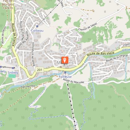
18. Morgins - Foilleuse
Description
Hiker's choice! This can be an easy downhill ramble or a challenging uphill workout between Morgins and the Foilleuse chairlift.
Starting at the bottom station of the Morgins gondola lift , the trail passes next to the bar called Chez Marie. Just past the chalet, take the large path on your left. Pass under the gondola lift, then look for the first round snowshoe sign direction Savolaire.
At the crossroads, turn right into the forest following the Madzé snowshoe signs.
At Madzé, take the wide path on your right, signposted Foilleuse. Take the left-hand path to the ridge and follow it to the top of the Morgins gondola lift . From here, you will enjoy one of the region's most spectacular views of the Dents du Midi and surrounding Alps.
Descent by gondola lift.
Variation:
Take the gondola lift up and hike down on snowshoes:
Duration: 1h45 via Abérieu (very steep) or 2.5 hours via Savolaire (recommended):
When leaving the cable car, turn left, walk along the cable car building and pass to the left of the end of the beginners’ ski carpet and to the left of the Luge Park, where you will find the first snowshoe signpost. Follow the signs advertising the mountain restaurant Gîte d’alpage La Chaux (the track is usually signed using their snow quad), descending to the right along a wide path while enjoying the mountain views. Pass the first farm and continue downhill along the road to the farm at the hairpin bend. Leave the La Chaux signposting (which goes off to the right—unless, of course, you wish to stop there for a gourmet break) and head left onto a small, flat path, before descending with a left-hand turn through the forest. Join a flat road, which you follow to the right for 500 m to reach the Madzé crossroads. We then recommend taking the loop via Savolaire/Champarin rather than the steep path that descends directly to Morgins.
Parking available in Morgins village centre.
Technical Information
Altimetric profile
Starting point
Points of interest


Additional information
Updated by
Région Dents du Midi SA - 17/02/2026
www.regiondentsdumidi.ch
Report a problem
Contact
Phone : +41 24 477 23 61
Email : morgins@rddm.ch
Website : https://www.regiondentsdumidi.ch/fr/region/morgins
Facebook : https://www.facebook.com/regiondentsdumidi
Data author
