Alert
Alerts
Snowshoe trail - Pas de Morgins
Description
This very easy route, accessible to all, will take you from Châtel through the forest to Morgins Lake in Switzerland.
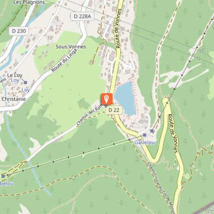
From the centre of Châtel, head towards Lac de Vonnes, where the path starts at the car park for the inter-domain link.
You can get there by taking the line 4 shuttle bus and getting off at the "Gabelou" stop.
From the signpost opposite the car park entrance, follow the path up to the Col de Morgins.
You are now on the border with Switzerland, and you can go as far as the lake of the same name just after the pass. The view opens out onto the Dents du Midi in Switzerland, dominated by the Haute Cime (3,257m).
If it's not covered in snow, the border marker at the pass is very interesting, with carved shields on either side (Swiss and Duke of Savoy).
Return by the same route or by taking the shuttle bus.
Alternative route: From Lac de Vonnes, walk alongside the lake and then, at the end of the lake, follow the small road leading to the start of the Vonnes link. Cross the road over the footbridge to reach the car park on the left.
Technical Information
Altimetric profile
Starting point
Points of interest

Date and time
- From 21/12/2026 to 21/04/2027
- From 21/12/2027 to 21/04/2028
Additional information
Open period
From 21/12 to 21/04 daily.
Accessible according to climatic conditions and is closed if the avalanche risk is 3 on 5. Please contact the Tourist Office in advance to find out the conditions of access at the time.
Subject to snow conditions.
Updated by
Châtel Tourisme - 21/04/2026
www.chatel.com
Report a problem
Environments
Mountain view
Forest location
Lake view
Mountain location
Contact
Phone : 04 50 73 22 44
Email : touristoffice@chatel.com
Type of land
Non-groomed itinerary
Location complements
Shuttle line 4, stop "Gabelou".
Car park.
Topo guides and map references
Topo guides references :
Free downloadable guide to snowshoe trails in the Vallée d'Abondance. Paper version available from Châtel Tourisme for €1.
Reception complements
Safety and rules of good practice:
- All routes are undertaken at the hiker's own risk, as they are not supervised.
- Before setting off, make sure you are aware of the weather conditions and the risk of avalanches, and remember to bring warm, waterproof clothing. Mountain weather changes very quickly. A high avalanche risk means that trails are closed.
- Choose a route suited to your level and physical condition.
- Follow the signposting instructions.
- Do not stray from the marked routes.
- Tell someone close to you about your outing and the route you have chosen.
- Never hike alone.
- Don't leave too late in the afternoon to make sure you're back before dark.
- Do not use the cross-country or downhill ski runs. Crossing the pistes is only permitted on marked crossings.
- Take plenty of food and water with you. Mountain sports require a lot of energy. Mountain inns and high-altitude restaurants exist on certain routes.
Equipment required :
- A hat
- Gloves
- Sunglasses
- Poles
- Mountain boots
In the bag :
- Warm clothing
- Hot drinks and snacks
- Mobile phone
- First-aid kit
- Sun cream.
Animals
Yes
Data author
