Alert
Alerts
Tour du Téton de Vénus
Description
An aerial and quite physical itinerary that culminates at 1700 metres at the summit of the Bec de L'Aigle rock. From here, a 360° view allows you to appreciate the expanse of the great Cantalien volcano strato, which you can follow with your eyes as you climb to the summit of the Téton de Vénus.
Technical Information
Altimetric profile
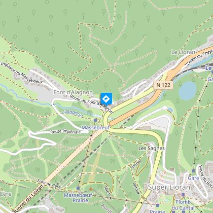
Starting point
Steps
Points of interest


Additional information
Updated by
Hautes Terres Tourisme - 24/11/2025
www.hautesterrestourisme.fr
Report a problem
Environments
Forest location
Mountain view
Mountain location
Close to GR footpath
Less than 10 min walk from a train station
Less than 10 minutes from a train station by bike
Less than 10 minutes from an SNCF train station by electric bike
Tips
-For your safety, please check the weather forecast before setting off on your hike. -To preserve the environment in which you are located, please avoid leaving garbage in nature. -Remember to take the appropriate equipment for the weather conditions and the hiking itinerary (hiking boots, water bottle, cap, sunglasses, jacket...).
Open period
All year round.
Subject to favorable snow and weather conditions.
Type of land
Rock
Stone
Ground
Grit
Not suitable for strollers
Contact
Phone : 04 71 49 50 08
Email : contact@hautesterrestourisme.fr
Website : https://www.hautesterrestourisme.fr
Tricky passages
Steep ascent from Font d'Alagnon to Bec de l'Aigle, with a short rocky section that is very steep and slippery in wet weather as you approach Bec de l'Aigle. Passage over a ridge, not for those prone to vertigo.
Guidebook with maps/step-by-step
Start - With your back to the sports sign, go back up to the road and cross it. At the start sign, continue along the narrow road for about 20 metres. Before the chalet, turn left and take a wide track up to the crossroads.
1- At the intersection, turn right and continue on the large forest track for about 150 metres. At the next crossroads, take the track which rises to the left. The track rises into the fir forest. Keep to the main track, ignoring intersections. The path becomes narrower and enters the beech forest. Follow the signs until you leave the wood. Continue to climb through broom heath to reach a flat area in a summer pasture (beware of herds).
2- Turn left and continue into the meadow, heading for the Rocher du Bec de l'Aigle. When you reach the base of the rock, follow a path around it to the left. After passing the large rut, continue on the track, which becomes stony and climbs to reach the ridge and then the Bec de l'Aigle pass (1700 m).
3- Take the ridge path overlooking the Roches de Vassivière, cross the gate and pass under the Téton de Vénus, which can also be climbed (1669 m) to enjoy a magnificent view of all the surrounding valleys and peaks. Pass under the Puy de Bataillouze and reach an intersection.
4- Turn left, and descend into the broom heath to find the Meije-Coste buron (guarded refuge). After the buron, take the trail down to the bottom of the Font d'Alagon glacial cirque. Cross a gate, continue downhill and reach the crossroads of the pistes.
5- At the crossroads, turn left onto the main track for a good kilometer. This takes you back to Font d'Alagnon and the starting point.
Animals
No
Data author
