Alert
Alerts
Hiking at Tréchauffé summit


Description
A hike that starts with a climb to the Col de l'Aiguille, with the goats to accompany you and keep you company, then the path climbs through the forest to reach the Pointe de Tréchauffé and its magnificent panorama of Lake Geneva.
From the summit you can also enjoy views of the Vallée d'Aulps peaks and the Swiss Jura.
Technical Information
Altimetric profile
Starting point
Points of interest
Date and time
- From 01/05/2027 to 31/10/2027
Additional information
Open period
From 01/05 to 31/10 daily.
Accessible outside the snow season and subject to weather conditions. Check with the Tourist Office beforehand for current access conditions. Recommended season: spring - summer - autumn.
Updated by
Vallée d'Aulps Tourisme - 22/04/2026
www.valleedaulps.com
Report a problem
Environments
Mountain view
Lake view
Mountain location
Contact
Phone : 04 50 79 65 09
Email : info@valleedaulps.com
Website : https://www.valleedaulps.com
Facebook : https://www.facebook.com/valleedaulpstourisme
Type of land
Not suitable for strollers
Stone
Grit
Ground
Location complements
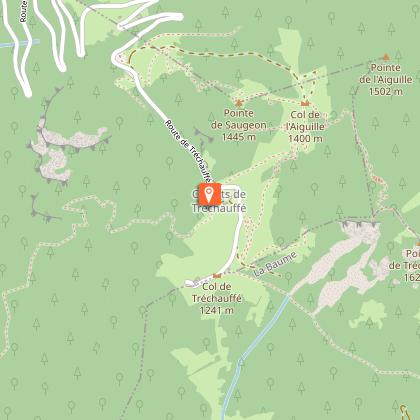
Departure from the Tréchauffé parking lot, opposite the goat farm.
> Access by car from Thonon or Cluses on the D902 to the village of La Forclaz, then follow the signs for Col du Grand Taillet and the chalets de Tréchauffé. Go to the end of the road.
Topo guides and map references
Map references :
Map: IGN Top 25, 3528 ET, Morzine
Reception complements
- Choose your route according to your physical condition and the weather conditions.
- Follow the instructions for signposting.
- Don't set off too late in the afternoon, to make sure you're back before dark.
- Take sufficient food and water with you. Mountain sports require a lot of energy.
Guidebook with maps/step-by-step
> Departure from the Tréchauffé parking lot (located after the belvedere and after the chalets de Tréchauffé)
1/ From the parking lot, retrace your steps for 300 m along the road towards the Chalets de Tréchauffé.
2/ Take the path on the right towards the Pointe de Tréchauffé.
3/ At the Col de l'Aiguille, take the right-hand path through the forest until you reach a very steep section equipped with metal steps to make the climb easier.
4/ At the summit, leave the path to reach the Pointe de Tréchauffé on the right, some 50 m away.
> Return along the same path.
Animals
Yes. Dogs must be kept on a leash due to the presence of herds.
