Alert
Alerts
Type of practice
Walking
Easy
3h
Presentation
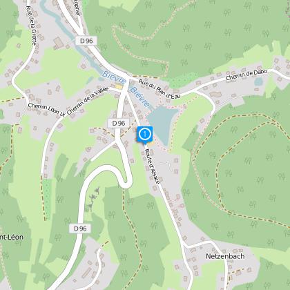
Map
Steps
Points of interest
Cirkwi brief's
Ratings and reviews
See around
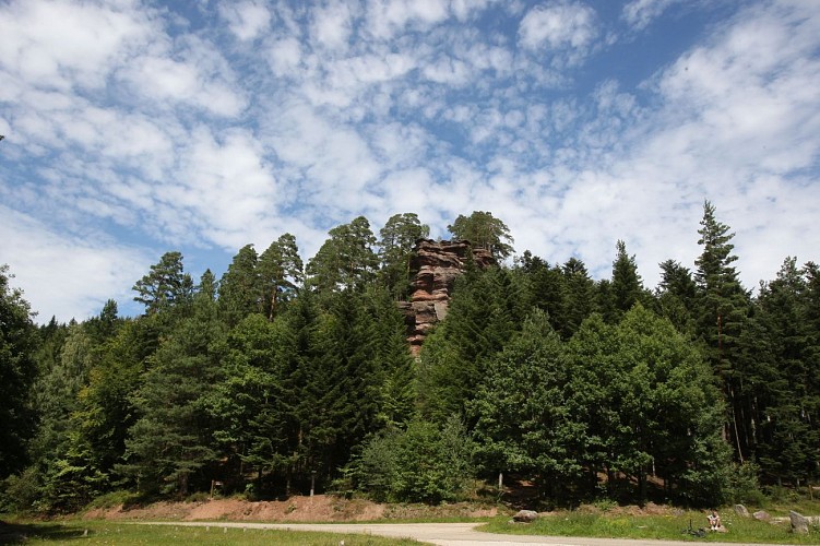
Route n°6: Path of the Rocks, proposed by the Montagnarde veterans. Please note: - Do not translate proper names. - Respect the subtleties.


Credit : Jean Claude Kanny - Moselle Tourisme
The Cirkwi brief
Explore Majestic Alsace Rocks: A Scenic Hiker's Journey
Embrace the allure of the Alsace forest as you embark on the enchanting 'Sentier des Rochers', offered by the proud veterans of La Montagnarde. This journey commences with a quaint trail that leads you through the heart of Walscheid forest, unveiling the spectacular view from Hohwalsch rock, a climber's delight. The adventure continues, weaving through an array of erosion-carved marvels including the Petit Hohwalsch rock, Gabriel rock, the Virgin rock, and finally the Raidisfels rock - a historical canvas where fugitives from the last war left marelle game inscriptions. Crafted by TOURISME WALSCHEID, this route invites you to immerse in nature's artistry and history.
Intense Trail Specs: Your Guide
Navigating the 'Sentier des Rochers' presents an engaging challenge with a total distance of 8.85 km. Starting at an altitude of 333m, climbers reach the zenith at 540m, tackling an overall positive elevation gain hovering around 655m. This moderate to difficult trek demands good physical condition, with steep inclines and rough terrain testing hiker endurance. The route's terrain and elevation profile are designed for those who seek to push their limits while being rewarded with unparalleled natural views.
Seasonal Tips for Safe Trekking
To experience the 'Sentier des Rochers' at its best, timing and preparation are key. In spring, the melting snow can render paths slippery; sturdy shoes and caution are advised. Summer, with its lush greenery, invites longer daylight trekking but necessitates hydration and sun protection. Autumn dazzles with colorful canopies, ideal for photography, yet early dusk requires vigilant time management. Winter snows introduce a magical white cover, yet demand high-grade winter gear. Remember, safety is paramount; always inform someone of your trekking plans, regardless of the season.
Walscheid: A Tapestry of Heritage
Walscheid, embedded within the Alsace region, stands as a witness to a rich history and cultural tapestry. This forested land has been shaped by millennia of human endeavor, from prehistoric settlers to wartime hideouts, as illustrated by the Raidisfels rock engravings. Alsace, with its unique Franco-German heritage, showcases a blend of architectural marvels, culinary traditions, and linguistic nuances, making Walscheid not just a starting point for hikes but a gateway to exploring a vibrant cultural landscape.
Weather Patterns and Best Visit Times
Walscheid, situated in Alsace, enjoys a continental climate marked by warm summers and chilly winters. Spring (April to June) offers a refreshing landscape, blooming with flora, making it an inviting time for hiking enthusiasts. However, rainfall can be frequent, so waterproof gear is suggested. The best period for hiking, though, falls between late August and October, when temperatures are moderate, precipitation is lower, and the forest presents a mesmerizing palette of autumn colors. Always check weather forecasts before embarking on your journey to ensure an enjoyable and safe hiking experience.
Automatically generated.
Technical Information
Walking
Difficulty
Easy
Duration
3h
(1d)
Dist.
8.8 km
Type of practice
Walking
Easy
3h
Show more
Altimetric profile
Starting point
8
Route d'Alsace
,
57870
Walscheid
Lat : 48.6455Lng : 7.15566
Points of interest
Data author

Ratings and reviews
To see around