Snowshoeing itinerary "Le Chemin des Hameaux" (1)
Description
[Saint François Longchamp]
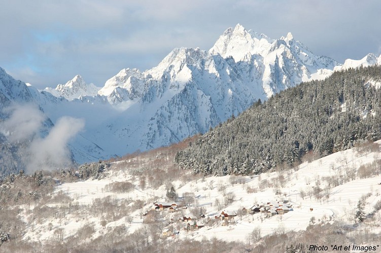
A beautiful familial stroll, twisting on the heights of the ski resort. It will offer you a point of view on the "Aiguilles d'Arves", the Belledonne and the Maurienne Valley.
Le chemin des hameaux
Departures: There are two possible departure points: from "Les Pérelles", at the top of the resort, or from the hamlet of "Cochenières", on the road to Montgellafrey.
The route forms a loop. A "Chemin des hameaux" sign marks the start.
From Les Pérelles, follow the path downhill, signposted with yellow markers. The path splits in two after 20 minutes. Turn right and descend for 25 minutes to the hamlet of Replat, then continue flat for 15 minutes to the hamlet of Cochenières. From here, you can loop back up to Les Pérelles (45 mins) or join the Montgellafrey road, which will take you back to the resort (20 mins), or cross the road and follow the Cochenières path to Place de la Madeleine (40 mins).
Points of interest: Family walk, on the heights of the resort. Open views of the Aiguilles d'Arves, the Belledonne mountain range and the Maurienne valley.
Tour duration : Approximately 1h45 (return).
Difficulty: Easy / medium (if there is not too much snow).
Difference in altitude: 155m.
Tips: Bring snowshoes if the snow is fresh. Be careful, the path can be muddy when the snow melts.
Translated with www.deepl.com/translator (free version)
Technical informations
2.9 km
|
max. 1707 m
min. 1521 m
155 m
155 m
| |||
Accessibility | ||||
Style : Mountain | ||||
Altimetric profile
Starting point
Steps
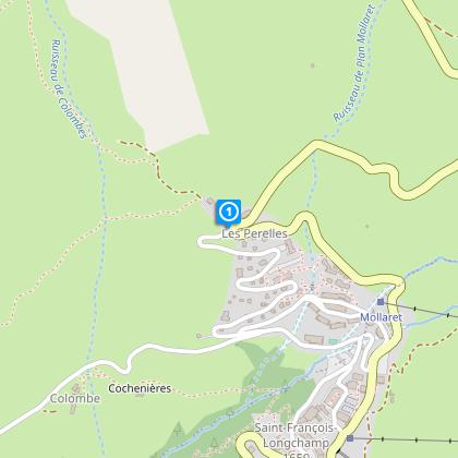
Les Perelles
Au départ des Pérelles, suivre le sentier en descendant, balisé par des jalons jaunes. Le sentier se sépare en deux au bout de 20 mn. Prendre sur la droite et descendre durant 25mn, jusqu’au hameau du Replat, puis continuer à plat pendant 15mn, jusqu’au hameau de Cochenières. Intérêts : Balade familiale, sur les hauteurs de la station. Vue dégagée sur les Aiguilles d’Arves, la Chaîne de Belledonne et la vallée de la Maurienne. Sentier ensoleillé.
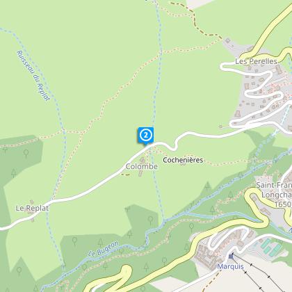
Cochenières
De là, vous pouvez remontez vers Les Pérelles (45mn) en faisant une boucle ou rejoindre la route de Montgellafrey, qui vous ramènera vers la station (20mn) ou traverser la route et enchainer sur le sentier de Cochenières, qui mène à la Place de la Madeleine (40 mn).
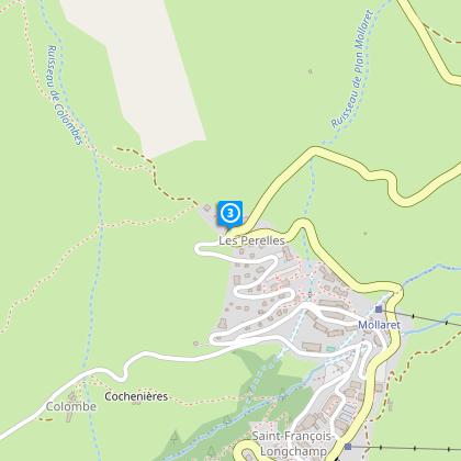
Les Perelles
Retour au point de départ
Date and time
- From 19/12/2024 to 15/04/2025
- From 19/12/2025 to 15/04/2026
Additional information
Reception conditions for animals
Dogs must be leashed
Updated by
Office de Tourisme de Saint François Longchamp - 24/04/2024
saintfrancoislongchamp.com
Report a problem
Environments
Near shuttle stop
Mountain view
Mountain location
Close to a public transportation
Village 2 km away
Open period
From 19/12 to 15/04.
Contact
Phone : 04 79 59 10 56
Tricky passages
If you are not accompanied by a mountain leader, make sure you have the avalanche safety equipment.
Topo guides and map references
Topo guides references :
"Hiking guide", free edition, Tourist Office St François Longchamp
Map references :
TOP 25 IGN 3433 ET
Type of land
Not suitable for strollers
Location complements
Motorway access: A43, exit 26 "La Chambre" (Attention in WINTER the GPS indicates to go through the Col de la Madeleine from Albertville and Montgellafrey village. The Col de la Madeleine is closed in winter and the road between the village Montgellafrey and Saint-François Longchamp. Special equipment are required in case of snow).
Train Station access : Train station "Saint-Avre / La Chambre". Shuttle bus between the station and the resort.
Airport access: Lyon, Chambery, Grenoble, Geneva.
In winter, access can be by the free bus shuttle and access on foot.
In summer, you can park nearby.
