Alert
Alerts
Walking route: Boucle des Plagnes


IGN cards


Description
A beautiful panoramic walking trail on the moutain alpine of Abondance with a view on the Switzerland and Chablais peaks, and a discovery of the mountain chalets.
This moderate hike invites you to discover the mountain pastures on the southern slopes of Mont de Grange.
Lac des Plagnes and the Cubourré site are part of the Chablais Unesco Geopark. From glaciers to bulging peat bogs, the trail around the lake takes you through landscapes that have evolved over the past 20,000 years.
You'll then cross the Montagne de Lens, where the word "Montagne" refers to the mountain pastures where pastoral activities are practiced. You can take advantage of the "chèvre" (a wooden fountain carved out of a tree trunk) to refresh yourself.
You will then reach the chalets de Lenlevay, the highest point (1733 m), with an exceptional panorama of the Swiss peaks and the Chablais, via a short section of the GR5. The path crosses alpine meadows and rhododendron heaths, the natural habitat of capercaillies.
The descent takes you past traditional mountain chalets and small chapels and oratories.
Technical Information
Altimetric profile
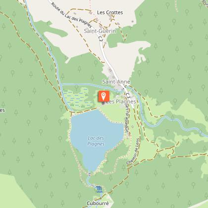
Starting point
Points of interest


Date and time
- From 01/06/2026 to 15/10/2026
Additional information
Contact
Phone : 04 50 73 02 90
Email : abondance@ot-peva.com
Website : https://leman-mountains-explore.com
Open period
From 01/06 to 15/10 daily.
Check with tourist offices in advance to find out the current access conditions.
Subject to favorable snow and weather conditions.
Updated by
Office de Tourisme Leman Mountains Explore - 24/11/2025
leman-mountains-explore.com
Report a problem
Environments
Lakeside or by stretch of water
Forest location
Lake view
Waterside
Type of land
Stone
Ground
Grit
Not suitable for strollers
Topo guides and map references
Topo guides references :
Hiking maps and guidebooks are available for purchase at tourist offices throughout the Evian and Abondance Valley region.
Map references :
- Map guide to 65 walks and hikes in the Evian region and Abondance valley
- Map of walking routes in the Portes du Soleil area in France and Switzerland
- IGN TOP 25 No. 3528 ET Morzine Chablais Massif Portes du Soleil
Location complements
Parking at the Lac des Plagnes, located 10 minutes by car from the centre of the village of Abondance, take the direction of Lac des Plagnes.
Reception complements
Whatever your hike, remember to take cereal bars, sufficient water, sunglasses, sun cream, a small first aid kit, as well as clothes adapted to your outing according to the season and the weather forecast.
Tricky passages
Late snow between the Tindérêts refuge and the Chalets de Lens.
Guidebook with maps/step-by-step
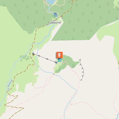
1/ Reach the edge of the lake and follow the signs for "Chalets de Lens". Join Cubourré. 2/ Follow the trail up the combe d'Ardens. 3/ Then take the trail up to the "refuge des Tindérêts". 4/ Take the path above the refuge through a copse of green alders. 5/ After crossing the large schist corridor, join the "Aup Couti". This last passage can be tricky for those with no previous experience in the mountains. 6/ Take the trail to the left to reach the "alpage de Lens". After 200 m, you'll come to the "Montagne de Lens". 7/ Continue down the path to the "Chalets de Lens". At the crossroads, you can shorten the circuit by returning to the Plagnes parking lot in 45 minutes (alternative). 8/ Head towards "Lenlevay". After a long but easy climb, you reach Les Covagnes, on the GR5. 9/ Turn left towards Lenlevay, just before the chalets, take the "Chalets du Jouly Haut puis Bas" trail on the left. 10/ Continue along this path as far as the "Les Trables" oratory, then take the left-hand trail down through the grass, which joins an old path through the forest. 11/ Turn left towards "Tetagottay", then right down to the edge of the meadow. Lac des Plagnes can be seen at the bottom of the valley, and you're almost there.
Animals
Yes. Dogs must be kept on a leash due to the presence of livestock and wildlife.
