Alert
Alerts
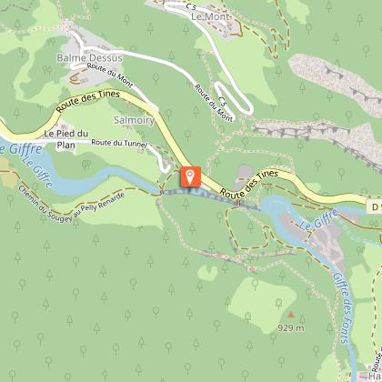
Walking itinerary : Les Gorges des Tines


IGN cards


Description
Discover the Gorges des Tines, a natural site of Sixt-Fer-à-Cheval. An ideal walk in hot weather that will delight the whole family!
From the Gorges des Tines car park, cross the footbridge over the gorges... Follow the path to your left just after the bridge. You'll then come to the entrance to the gorges and start heading down a forest path. When you reach the gravel pits, go up the path equipped with a hand rail and follow this as far as the forest. Continue uphill, following the "Gorges des Tines" trail on the GR itinerary, which then takes you down some steps before entering the old gorges which are also equipped with steps. On exiting the forest, the path rejoins the Giffre river, which you'll follow on the right back to your departure point.
Technical Information
Altimetric profile
Starting point
Points of interest

Date and time
- From 01/05/2026 to 30/11/2026
Additional information
Open period
From 01/05 to 30/11 daily.
Subject to favorable snow and weather conditions.
Tips
If you'd like to extend your hike, it's possible to start from the Tourist Office!
Updated by
Conseil Départemental de la Haute-Savoie - 24/11/2025
www.hautesavoiexperience.fr
Report a problem
Environments
Riverside
Mountain view
Mountain location
Contact
Phone : 04 50 34 49 36
Email : contact@haut-giffre-tourisme.fr
Website : https://www.haut-giffre.fr/
Type of land
Stone
Ground
Grit
Not suitable for strollers
Location complements
Access (by car): From Cluses, join Taninges (D902), then the village of Samoëns via Morillon. From Samoëns, head for Sixt-Fer-à-Cheval (D902), and you'll soon reach the Gorges des Tines parking lot on your right.
Access (bus) : Accessible by shuttle bus in summer.
Topo guides and map references
Map references :
TOP 25 IGN 3530ET - SAMOENS
Reception complements
Whatever your hike, remember to pack cereal bars, plenty of water, sunglasses, sunscreen, a small first-aid kit, and clothing appropriate to the season and weather forecast.
Tricky passages
In wet weather, the metal ladders used for hiking can be very slippery.
Guidebook with maps/step-by-step
1/ Departure point: Les Tines parking lot
2/ From "Les Tines (Parking)", follow signs for "Anciennes Gorges des Tines par Bord du Giffre".
3/ At the "Passerelle des Tines" signpost, head towards "Anciennes Gorges des Tines". Cross the footbridge over the gorges and follow the path to the left. Continue in the direction of "Anciennes Gorges des Tines", passing the following signposts: "Bord du Giffre", "Le Béné" and "Dessus les Tines".
4/ At "Anciennes Gorges des Tines", follow "Les Tines (Parking) par Pelly Renadé", then return to your starting point via "Pelly Renadé".
Animals
Yes. Caution: be able to carry your dog over ladders.
Pets allowed on leash only.
Data author
