Alert
Alerts
Mont Jovet loop
1 alert on this circuit
Visitor alert
We advise you to keep your dog on a leash due to the presence of livestock and in order to protect wildlife.
Interactive map to locate guard dogs in Savoie: www.pasto-kezako.fr/mappatou/


Description
This route gives you a beautiful 360° panoramic view when the weather is good. You can see the Mont Blanc, the Vanoise, the Cervin, the Ecrins...
You have got a refuge on the route if you want to eat something.
Start: At the first roundabout in Bozel, take the direction of Villemartin. Follow the road after Villemartin in the direction of La Cour, you can park your car at the end of the village. You have got two different paths to go to the Mont Jovet.
Either through the Bois de la Cour:
The path starts from the heart of the village. The path is quite nice within the forest. You have to follow the direction of la Grande Roche. You can follow the signs to the Mont Jovet.
Go back from the Bois des Perrières to make a loop.
Or through the Bois des Perrières:
You have to keep going after the village of la Cour until the river where you can park your car. Take the path on the left side of the river. The path which is going through the forest is quite steep. Follow the direction of the Mont Jovet.
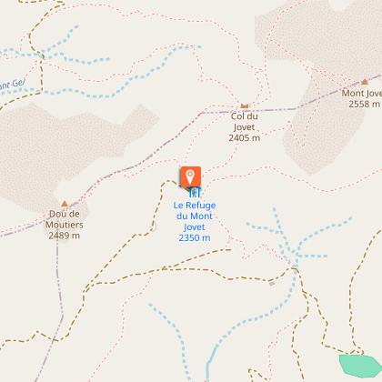
When you are at the refuge (2349m), follow the path to the Mont Jovet which allows you to go at the top (2558m). You will find there a beautiful view.
If you want, you can have access to the refuge through a carriage way that starts from la Cour.
The refuge of the Mont Jovet is open from mid-June to mid-September. Information: +33(0) 6 20 71 86 25.
This walk is medium, there are no big difficulties.
Technical Information
Altimetric profile
Starting point
Points of interest


Date and time
- From 01/06/2026 to 31/10/2026
- From 01/06/2027 to 31/10/2027
Additional information
Contact
Phone : 04 79 55 03 77
Email : info@valleedebozel.com
Website : http://www.valleedebozel.com
Facebook : https://fr-fr.facebook.com/ValleedeBozel/
Open period
From 01/06 to 31/10 daily.
Depending on snow conditions.
Environments
Mountain view
Mountain location
Type of land
Ground
Not suitable for strollers
Topo guides and map references
Map references :
TOP 25 IGN 3532OT
TOP 25 IGN 3534OT
TOP 25 IGN 3532ET
Updated by
Communauté de Communes Val Vanoise - Vallée de Bozel Tourisme - 19/02/2026
www.valleedebozel.com
Report a problem
Reception complements
Security
Take the weather forecast before leaving.
Don’t forget to drink to eat and have a break.
Equipment
Equip yourself with good shoes and clothes well suited for mountains.
Carry IGN map. This map is provided for information purposes only.
Good behaviour
Stay on track.
Respect the environment .
Be careful with herds, keep your dog on leash.
Be careful with your waste, bring it back with you.
Guidebook with maps/step-by-step
Start: La Cour 1,527 m
1/ Turn right and take the forest track for a few metres 1,600 m
2/ At the crossroads, cross the forest track and continue straight ahead 1,771 m
3/ Continue straight ahead on the path (Grande Roche viewpoint on the left) 1938 m
4/ At the junction with the track leading up to the Mont Jovet refuge, turn right to rejoin the path a few metres further on. 2,280 m
5/ Mont Jovet refuge: continue along the path that climbs to the right behind the refuge 2,348 m
6/ Take the path that climbs to the right 2,420 m
7/ Mont Jovet 2,558 m
8/ Take the path that descends to the left 2310 m
9/ Turn left at the junction with the track and follow it for a few metres 2250 m
10/ Take the path under the track, on the right 2250 m
11/ Arrival at the Grand Rey farm, take the track for about a hundred metres 2050 m
12/ Take the path under the track on the right 2040 m
13/ Take the path downhill on the right 1910 m
14/ When you reach the road, turn right and follow the road downhill to the starting point. 1582 m
Animals
Yes. We advise you to keep your dog on a lead due to the presence of livestock and therefore guard dogs, and in order to protect wildlife.
