Combe Fort and Pointe de la Fougère


Description
Set in a wild and unspoiled landscape, you enter one of the natural sanctuaries of Bauges. You'll have great opportunities to see chamois, roe deer or mouflons which are numerous in this area.
50 metres after the car park, ford the torrent. Go up a trail crossing sometimes steep woods, and then a stream again.
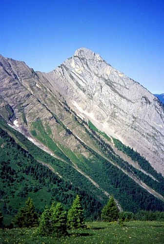
At around 1,450 m we come out onto Combe Fort. The path goes left in the high grass where the mountain flora is particularly varied. The trail crosses the steep grassy slopes facing you and then reaches the wooded ridge leading to the Pointe de la Fougère (1,849 m) and the route downhill. Climb to the top (40 minutes).
Come back down the same way, then via the zigzagging path which crosses the steep forest of the Fougère. You return to the starting point via the road closed to traffic.
If you do the route the other way round, check the river flow for fording it on your way back.
Technical informations
11 km
|
max. 1606 m
min. 999 m
850 m
850 m
| |||
Altimetric profile
Starting point
Date and time
- From 01/05/2024 to 31/10/2024
- From 01/05/2025 to 31/10/2025
Additional information
Updated by
Grand Chambéry Alpes Tourisme - 17/04/2024
www.chamberymontagnes.com
Report a problem
Open period
From 05/01 to 10/31 : open daily.
Contact
Phone : 04 79 54 84 28
Email : accueil.bauges@chamberymontagnes.com
Website : www.chamberymontagnes.com/randonnees-et-trail/
Facebook : www.facebook.com/bauges
Data author

