Climb to Bostan

Description
This hike takes you through mountain pastures to the Bostan hut.
Starting altitude: 1,096 m
Finishing altitude: 1,769 m
Particular difficulties: none
Itinerary for guidance only.
Technical Information
Altimetric profile
Starting point
Points of interest

Bostan mountain refuge
Above Samoëns and isolated in the mountains, the Bostan refuge is the ideal place to welcome hikers for a short break or for the night. Accommodation and catering in the mountains. Home and local products. Pleasure for the eyes and taste buds. .It overlooks the Giffre valley and the town of Samoëns. - In summer, it is easily accessible on foot, for everyone in around 1 hour 45 minutes from the Allamands car park and gives the possibility of trekking in a loop for a day or over several days. - In winter, the valley is a classic for all levels, both on skis and on snowshoes (Col de Bostan - head of Bostan) - about 2 hours. At the refuge, you will find a warm welcome in a friendly atmosphere. You can eat at noon, and in the evening you quench your thirst at any time and sleep (it is recommended to book in advance).

Hamlet of the Allamands
The origin of the hamlet of the Allamands on the commune of Samoëns dates back to the 13th century. This atypical and picturesque place in Haute-Savoie has preserved many traces of the past.The route des Allamands leads to the Col de la Golèse and the Morzine valley, and further on via the Col de Coux in the Swiss Valais. A strategic position therefore. This explains why this village was very densely populated until the interwar period. With its 19th century chapel, oratory, basin, typical farms and picturesque houses, it reflects the life of the past. An authenticity that this septimontine hamlet still preserves today. And this, to the delight of visitors. The origin of the hamlet, one of the nine of Samoëns, dates back to the beginning of the 13th century. At that time, the mountains of Samoëns in the Haut-Giffre valley were covered with immense wild and wooded areas. The place was isolated and not easily accessible. In order to enhance the area, set back the forest and enlarge the clearings, the lords, with the consent of the monks, installed families of German-speaking lumberjacks there. This is where the hamlet gets its name from. It was these woodcutters who then cleared the mountain pastures of Bostan and Odda, whose names are of Germanic origin. Bostan comes from Bostâr meaning "wood" and Odda meaning "precious thing". In 1476, the Bernese troops reached Samoëns by the pass road, setting fire to the Allamands. The hamlet thus met the same fate as the Church of Our Lady of the Assumption in Samoëns. Half a century later, the village was again set on fire by troops of the League of Swiss Cantons. It is hard to imagine that this place, so peaceful and authentic today, was a few centuries ago, surrounded by hostile nature and subject to invasions.
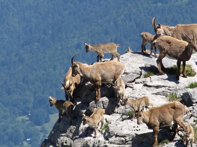
Tête de Bostan
2,295 metres is the altitude of Bostan's head. The hike from the eponymous hut requires a good two hours of easy climbing.Here, the view has no need to worry about the border limits between Haute-Savoie and Valais Switzerland. The peaks of the nearby Chablais and the Morzine valley block the horizon.

Bostan Refuge
Above Samoëns, this mountain chalet is situated under the "dents blanches", the highest point of the area. Its terrace is ideally oriented to the east for a view of the Giffre valley and allows you to enjoy the beautiful sunset.The refuge overlooks the Giffre Valley and the commune of Samoëns. A sunny terrace overlooking the valley where you can enjoy good omelettes and a beautiful sunset. Sleeping in several dormitories from 5 to 12 places. - In summer, it is easily accessible on foot, for all, in about 1h45 from the Allamands car park, and offers the possibility of day or multi-day hikes. - In winter, the refuge is located on the itinerary leading to the tête de Bostan, a great classic of ski touring in our valley. It is easy to access (2 hours) and the path is marked. It is an easy hike on snowshoes or ski touring.
Date and time
- From 11/06/2024 to 11/09/2024
- From 11/06/2025 to 11/09/2025
Additional information
Updated by
Office de Tourisme de Samoëns - 16/03/2024
www.samoens.com
Report a problem
Environments
Mountain location
Open period
From 11/06 to 11/09.
Contact
Email : nordic.hg@orange.fr
Website : www.valleeduhautgiffre.fr
Type of land
Stone
Ground
Not suitable for strollers
Topo guides and map references
Topo guides references :
Guide reference: Upper Giffre valley ramblers' guide.
Map references :
TOP IGN 3530 ET
Data author
