Alert
Alerts
Snowshoeing itinerary : Les Chapets
IGN cards


Description
Small hike in forest from "Le Plan" to access to the hamlet of "Les Chapets" with its beautiful view over the valley of "L'Arrondine".
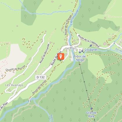
From the Plan car park, take the groomed path that runs alongside the Arrondine stream, walking near the toboggan area (Groomed route for the first 2.5 km only). Continue on a forest path towards Les Chapets, passing through "L'Armoy" and "Les Arsets". At this crossroads, take the climb to the left to join "Les Quatre Chemins", and the Chalets des Chapets. After admiring the panorama of the valley, return to the crossroads of the four paths, then turn right onto the track which winds its way between the trees. The bravest can make a round trip (20 minutes) to Les Chapets, the others will continue straight on the forest path of Golet and descend to join the ascent circuit before "Les Arsets".
The return to the Plan is made by the same route as for the outward journey.
Attention: after the Chapets, do not venture: significant avalanche risks.
Technical Information
Altimetric profile
Starting point
Points of interest


Date and time
- From 15/12/2025 to 15/04/2026
- From 15/12/2026 to 15/04/2027
Additional information
Updated by
Office de Tourisme du Val d'Arly - 10/10/2025
www.valdarly-montblanc.com
Report a problem
Environments
Mountain view
Mountain location
Ski resort
Bottom of slopes
Topo guides and map references
Topo guides references :
Map of snowshoeing and ski touring itineraries in the Val d'Arly on sale for 4€ in the Val d'Arly Tourist Offices (itinerary no. 16)
Map references :
Map of snowshoeing and ski touring itineraries in the Val d'Arly on sale for 4€ in the Val d'Arly Tourist Offices (itinerary no. 16)
Open period
From 15/12 to 15/04.
Subject to snow conditions.
Type of land
Groomed trail
Contact
Phone : 04 79 32 91 90
Email : sentiers@valdarly-montblanc.com
Guidebook with maps/step-by-step
1/ From the Plan car park, take the groomed path that runs alongside the Arrondine torrent, close to the sledging area (groomed path for the first 2.5 km only).
2/ Continue along a forest track towards Les Chapets, passing through ‘L'Armoy’ and ‘Les Arsets’.
3/ At this crossroads, turn left uphill to reach ‘Les Quatre Chemins’ and the Chapets chalets.
4/ After admiring the panoramic view over the valley, return to the ‘Quatre Chemins’ crossroads, then turn right onto the track that weaves its way through the trees. The most courageous will be able to make a round trip (20 minutes) to Les Chapets, while others will continue straight ahead on the Golet forest track and then descend to rejoin the uphill route before ‘Les Arsets’.
5/ Return to Le Plan via the same route as the outward journey.
Caution: do not venture beyond Les Chapets as there is a significant risk of avalanches.
Animals
No. Dogs are not allowed on the lower part of the itinerary, as it is used in conjunction with sled dog activities.
