Alert
Alerts
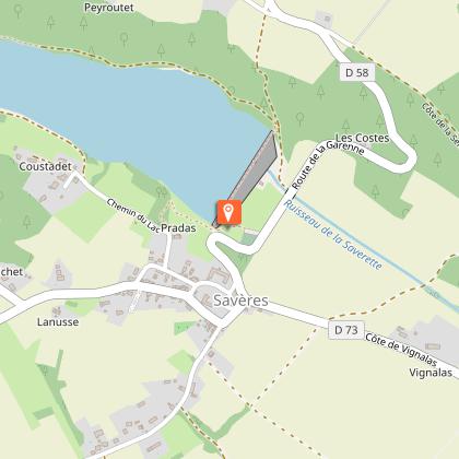
TOUR DU LAC DE SAVERES
Description
Start from the cemetery car park, D58.
Follow the gated path up to the dyke (yellow markings).
Follow the dam along its entire length.
At the end of the dam, turn left onto the path that runs alongside the lake on its north shore. At the crossroads, turn left and cross the Saverette by the wooden footbridge.
After crossing the river, turn left onto the track that runs alongside the Laroujat wood.
At the crossroads, you can make a short detour as far as the Stèle du Maquis (Maquis stele) by going straight ahead to the road, which you then follow on the left for 100 metres. Retrace your steps and take the path on the right at the crossroads to reach the ford.
Cross over and take the left-hand path alongside the lake.
Walk along the opposite side of the lake. Towards the end, the path moves away from the shore and joins a small road that you follow for 400 metres.
Turn left through the village to the church.
When you reach the church, take the road on the left that leads down behind the town hall to the D58. Turn left onto the road and rejoin the starting point.
Technical Information
Altimetric profile
Starting point
Additional information
Elevation gain
(Low)
Services at the starting point
Coach parking
Car parking
Start and end town
SAVERES
Contact
Website : tourismecoeurdegaronne.com
Email : tourisme@cc-coeurdegaronne.fr
Tel : 05 62 02 01 79
Data producer
Contact : HAUTE-GARONNE TOURISME / OFFICE DE TOURISME INTERCOMMUNAL COEUR DE GARONNE
Phone : 05 62 02 01 79
This information comes from the Haute-Garonne Departmental Tourism Network and is synchronized as part of the partnership between Cirkwi and Haute-Garonne Tourisme.
Data author
