Alert

Alerts

To see around
See more
Open
Close
Show
Show
Show
Show
Show
Show
Show
Show
Show
Show
Show

Oups... It would appear that Cirkwi does not have permission to use your location.

Presentation
Description
Map
Points of interest
Ratings and reviews
See around

Le Sentier Botanique

Le Sentier Botanique_Monoblet

Description

As in the rest of the Cévennes, sericulture developed in Monoblet in the early 18th century. It declined from the mid-19th century onwards, leaving behind a legacy of buildings and landscapes.

The route comprises 20 stations forming a loop around Monoblet. Enter the village from Saint-Hippolyte-du-Fort and Durfort. Pass in front of the town hall and continue along the main street for 200 m to the parking lot opposite the octagonal temple.

A LAND OF CONTRASTS
The commune of Monoblet covers 2,133 hectares, 1,400 of which are woodland and coppice, and offers a contrasting landscape between wooded reliefs of oak and chestnut, and valleys where agricultural activity continues to enliven the landscape. This relief is explained by the geological formation that divides the commune into two
distinct areas. To the north-west, the southern end of the granitic Cévennes, home to chestnut trees, and to the south, the limestone garrigues and marls
which form a zone of ecological, faunistic and floristic interest (ZNIEFF), named "Lapiaz de Curens", bordering Saint-Hippolyte-du-Fort.

THE IMPACT OF SERICULTURE ON MONOBLET'S LANDSCAPE
The silk and sericulture industries were among the population's primary resources, especially in the mid-19th century, which explains the presence of numerous silkworm nurseries and mulberry trees, whose leaves were the only food for silkworms. In the 1970s, sericulture was revived in this village.
village.

TRADE AGREEMENTS
On February 10, 1713, manufacturers from the main towns in the Cévennes - Saint-Hippolyte-du-Fort, Anduze, Ganges, Lasalle, Sauve, Le Vigan, Monoblet and others - signed an agreement which, with the blessing of the authorities, linked them to Nîmes merchants and manufacturers.
In this way, the towns in the hinterland safeguarded their production sector and ensured their domination over the rural manufacturers in their respective areas of influence, but in return, they gave up their desire to follow independent paths and willingly agreed to join the Nîmes factory. From then on, their makers could continue to work in their place of residence, on condition that they were accepted as masters in the Nîmes community, submitted to its regulations and contributed to its expenses.

INTERPRETATION STATIONS
1 - Mulberry tree
2 - Judas tree
3 - Chestnut tree
4 - Vine
5 - Badasse
6 - White oak
7 - Aphyllanthe
8 - Bituminous psoralea
9 - Olive
10 - Pewter Laurel
11 - Common thyme
12 - Holm oak
13 - Arbutus
14 - Mahaleb cherry
15 - Wild asparagus
16 - Corm tree
17 - Kokuzo mulberry
18 - Monoblet school and its green roof
19 - Place des Magnans
20 - The Gréfeuilhe workshop

Technical Information

Walking
Difficulty
Very easy
Duration
1h30mn
Dist.
2 km
Show more

Altimetric profile

Starting point

10 rue du Puits Neuf , 30170   Monoblet
Lat : 43.998615Lng : 3.883731

Points of interest

image du object

Le Sentier des Vestiges de l'Industrie de la Soie

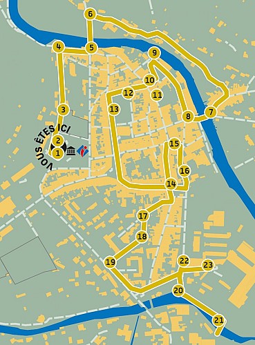
To complement the visit to the Musée de la Soie, the Silk Industry Remains Trail is an urban trail leading visitors to discover numerous silk-related buildings and remains.The route is made up of 20 to 23 stations (depending on the circuit chosen) that take you through the town and its history linked to sericulture. After 1750, the economy, which had just experienced a crisis, took off again with a new "product", silk imported from Asia. Specific buildings, known as magnaneries, were built to accommodate the ever-growing "educations" of "magnans". Spinning mills, stocking factories, knitting mills - silk held an important place until the early 19th century, when silkworm diseases (pebrine and flacherie) caused Lyon's industrialists to turn to foreign products rather than Cévennes' own. The advent of synthetic yarns sounded the death knell for the industry. 1 - SILK MUSEUM. - Departure point : Silk Museum parking lot (welcome sign). From the "Musée de la soie" signpost, head towards "Vidourle". 2 - THE FORMER 17th-century CASERNE was part of the military preparatory school (1886-1934). Take the Catholic cemetery crossing. 3 - SILKWORM NURSERY. Magnanerie architecture is characterized by narrow openings just below the roof. In the 19th century, when sericulture reached its golden age, these buildings were built solely for raising silkworms. Along the way, look out for the ancient ramparts on your right. Continue along the crossroads to the Catholic cemetery. 4 - THE ST JEAN TOWER. Resistance from the largely Calvinist population in the 16th century led to the building of ramparts leading to a fort and a watchtower to keep the town under the surveillance of the king's dragoons. From the tower, turn right, then left. 5 - LE VIADUC DE PLANQUE (railway line turned greenway). This was an essential part of the town's industrial development, as the "Nîmes - Le Vigan" railroad line enabled locally-produced silk to be exported to major industrial centers such as Lyon, and coal to be transported to the spinning mills. Cross the Vidourle over the bridge and turn right into Rue du Faubourg de Planque. 6 - CHÂTEAU DE PLANQUE AND MILLS. On the way, we pass two old mills that also functioned as which were also used as spinning mills. One of them still has a paddle wheel. You can see how the water from the Vidourle is channeled through a béal. Along the way, take a look at the town's old industrial district on the opposite bank. At the end of the street, turn right onto Faubourg du Vidourle to reach the signpost at the bottom of the bridge. 7 - VIEW FROM THE VIDOURLE BRIDGE. The old industrial quarter is clearly visible upstream from the Vidourle. The signpost takes you to rue de l'Agal. 8 - THE PUECH-ROCHER SPINNING MILL. With the arrival of the steam engine and the mechanization of factories, large With the arrival of the steam engine and the mechanization of factories, large buildings were built close to rivers to meet their growing water needs, and large bay windows were installed to let in as much light as possible. The Puech-Rocher spinning mill dates from the 19th century and operated until 1920. Follow rue de l'Agal. 9 - RUE DE L'AGAL. This district's activities (spinning mills, tanneries, dye works, draperies, etc.) were able to develop thanks to the supply of water from an underground canal, the Agal. At the "Agal" signpost, head for "Ecoles". 10 - LA MAGNANERIE BOURGUET. Located on the top floor of this large 16th-century building, this silkworm nursery shows the interest that wealthy owners took in the education of silkworms, to the point of enhancing their own homes. Enter Rue Pasteur. 11 - THE PASTEUR HOUSE. In 1869, Louis Pasteur came to spend a few months in Saint-Hippolyte-du Fort for his research into pebrine, a silkworm disease that decimated silkworm farms. Retrace your steps and take the Place du plan to reach the fountain. 12 - LES MAGNANERIES DU PLAN (place Jean-Jaurès). Around the square are several examples of family-run magnaneries. None resembles the other, but they are all characterized by their openings. Take the Cours Gambetta towards the cafés. 13 - PLACE DU PLAN. A field of mulberry trees was once planted here. Follow the Cours Gambetta to the Place de la Canourgue, then turn left into Rue de l'Argenterie. de l'Argenterie. 14 - LES GRANDES MAGNANERIES DE LA PLACE DU 19 MARS 1962... One of Saint-Hippolyte-du-Fort's wealthiest mansions. Established in the 19th century, the buildings were designed designed to accommodate a silkworm farm on the top floor. At the end of the street, turn left into Rue de l'Amiral Sap, then right. 15 - THE TOWN HALL. Under the arcades on the first floor, there used to be a market where producers sold their cocoons to traders. Pass in front of the town hall and turn right into rue Jacques Boudon. 16 - LA BONNETERIE BRETONVILLE... Next to the pond, you can make out the old hosiery factory at the far end of the courtyard. By the end of the From the end of the 18th century, Nîmes, Ganges and Saint-Hippolyte-du-Fort were major hosiery centers, producing silk stockings that were often embroidered and exported all over the world. At the end of the street, turn right into Place du 19 mars 1962, then left into Rue Fondeville and quickly turn right into the covered passage Impasse de Fondeville. 17 -THE PLANCHON ROCHEBLAVE SPINNING MILL. This spinning mill has undergone many transformations since its construction in 1824. It closed in 1937. Make a U-turn and turn right. 18 - MULBERRY FIELD. Exclusive food for silkworms, mulberry trees were planted in large numbers near the silkworm farms. There was a large mulberry field here. Continue along the street, then turn right to cross the garden, then cross the parking lot to reach the "Ecoles" sign on boulevard des Remparts. 19 - THE MOURGUES BOUSQUET FACTORY. Built in 1850 as a spinning mill, it was transformed into a hosiery factory in 1930 by the Lyon-Cévennes company, whose inscription can still be seen on the façade. It closed in the 1970s. At the "Ecoles" signpost, follow signs for "Argentesse". 20 - VIEW FROM ARGENTESSE. Opposite the Argentesse river, you can see the Baudoin hosiery workshops, which operated until the 1990s. Continue along the Chemin du Pont de secours to the bridge. 21 - LA MAGNANERIE DU PONT DE SECOURS. Following the river as far as the Pont de secours du Fort, you'll come across an farmhouse that once housed a silkworm nursery. The openings are narrow, as the isolated building faces the north wind. You'll notice mulberry trees all around. Make a U-turn on the Pont de secours road and turn right at the end of the road. 22 - THE TEMPLE. The largest in France. Make a U-turn and turn left into the street leading to the Fort (now Ets Jallatte). 23 - LE FORT. Part of the citadel (with ramparts and watchtower) built in the fight against the Camisards. Private site, not open to the public. End of the tour.

3 place du 8 mai 1945 30170 Saint-Hippolyte-du-Fort
- Gard Tourisme -
Consulter
image du object

Le Sentier des Fileuses

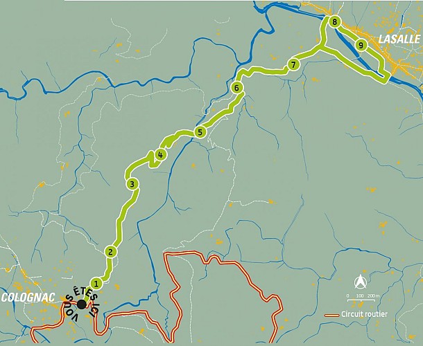
The "Carré de soie" (Silk Square) interpretation trail in Colognac follows part of the old draille linking Colognac to Lasalle. It was via "Le sentier des fileuses" that young girls used to travel to Lasalle to work in the spinning mills.Route with 9 interpretation stations between Colognac and Lassalle. START: parking lot at the entrance to the village, at the intersection of the D185 from Le Rédares and the D153 from Lasalle. HARD WORK The working day goes from "day to day", from dawn to night, and follows the rhythm of the seasons. Shorter in winter, it can reach sixteen to eighteen hours a day a day in summer. It's hard, repetitive work, in the hum of machines, humid heat and heavy smell. Wages were very low throughout the throughout the nineteenth century: 1.50 francs a day, but they represented a much-needed addition to the meager budgets of rural families. THE DEMOGRAPHIC IMPACT OF SERICULTURE Silk spinning generated a veritable industrial boom throughout the Cévennes Piedmont. In 1841, eight spinning mills were processing silk in the commune of Lasalle. of Lasalle, whose population had doubled in fifty years, reaching 2,500 by 1850. The staff were housed on site or came from the surrounding and hamlets in the surrounding mountains. 1 - La soie. une histoire vue par les femmes. 2 - A journey through the life of a silk spinner. The magnarelle "incubates" her magnan seeds. 3 - A path through the life of a spinner. The magnarelle "mothers" her magnans. 4 - Silk. A family affair: decocking takes place at home. 5 - The hardness of silk, from yesterday to today... 6 - Silk spinners make history. The spinner strike in Ganges in 1906. 7 - "Fairies" on the cradle of silk. 8 - Life in the Lasalle spinning mills. 9 - Life in the Lasalle mills.

Le village 30460 Colognac
- Gard Tourisme -
Consulter
image du object

Le Sentier patrimonial de la Soie

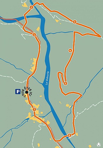
Departing from the village Temple parking lot, the Silk Trail is an easy 2 km walk that allows you to discover silkworm breeding. Silkworms were an important resource for the village's economy before they disappeared.A 7-station route around the village of Cros. The presence of the mulberry tree in Cros can be traced back to the early 18th century. It all began with this tree, whose leaves were needed to feed the manhan (the Occitan name for the silkworm, Frenchized as "magnan"). The boom in sericulture is generally attributed to the terrible winter of 1709, which froze the chestnut trees to the ground. Breeding lasts a few weeks, from April to July, and requires a large workforce or specialized rooms known as "magnaneries". When the magnan "encabana" in the heather twigs to weave its cocoon, rearing is complete and the cocoons must be "descoconar", removed from the twigs to be treated before the chrysalis pierces them. In the 18th century, cocoons were treated in "basins". In the 19th century, the cocoons were taken to spinning mills, reflecting the industrialization of the Cévennes. The two spinning mills in Cros supply raw silk (which still contains the silkworm's secretion, grès) to traders in the Cévennes, Nîmes and Lyon. The silk thread is then strengthened by twisting, and the sandstone is removed. Dyeing is then possible. From the early 17th century, silk from the Cévennes was used for weaving, but above all for making stockings, worn by men and women alike. Despite Louis Pasteur's intervention in Alès in 1865 and in Saint-Hippolyte-du-Fort in 1869, diseases decimated the farms: up to 80% losses in Cros in 1876 and 1878. Sericulture continued in Cros until the 1960s, when the cocoons were taken to the Maison Rouge spinning mill in Saint-Jean-du-Gard, the last silk spinning mill in France, which closed in 1965. Hosiery continued to exist in the Cévennes valleys in the 20th century. Today, only a few workshops bear witness to this industrial past. industrial past. In 1876, silk directly employed 13% of the working population of Cros. The golden age of sericulture in Cros lasted until the early 19th century, as evidenced by the evolution of the village's population. INTERPRETATION STATIONS 1 - The Italiennes oustalet. 2 - The Arnaudes mill. 3 - From crops to forest. 4 - The Mas Bourguet terraces. 5 - The hamlet of La Mazade. 6 - The Vidourle. 7 - The spinning mills.

D169 - La Mazadette 30170 Cros
- Gard Tourisme -
Consulter

Additional information

Updated by

Office de Tourisme Intercommunal Piémont Cévenol - 29/07/2026
piemont-cevenol-tourisme.com/
Report a problem

Environments

In the country
Mountain location

Open period

All year round daily.

Contact

Phone :
04 66 93 06 12
04 30 67 26 94

Email : tourisme@piemont-cevenol.fr

Type of land

Hard coating (tar, cement, flooring)
Suitable for city strollers

Location complements

Coming from Saint-Hippolyte-du-Fort and Durfort, enter the village. Go past the town hall and continue along the main street for 200 m to the parking lot opposite the octagonal
the octagonal temple.

Animals

Yes

Data author

Image Gard Tourisme
proposed by Gard Tourisme
13 rue raymond Marc 30000 Nîmes France

Ratings and reviews

To see around
See more
Open
Close
Show
Show
Show
Show
Show
Show
Show
Show
Show
Show
Show
Caution!
We have no information on the difficulty of this circuit. You may encounter some surprises along the way. Before you go, please feel free to inquire more and take all necessary precautions. Have a good trip! 🌳🥾