Alert

Alerts

To see around
See more
Open
Close
Show
Show
Show
Show
Show
Show
Show
Show
Show
Show
Show

Oups... It would appear that Cirkwi does not have permission to use your location.

Presentation
Description
Map
Steps
Points of interest
Ratings and reviews
See around

Saint Jacques de Compostelle - Bourg en Bresse to Ambronay

Saint Jacques de Compostelle - Bourg en Bresse to Ambronay

Description

A route to Santiago de Compostela, from the Brou monastery in Bourg-en-Bresse to Ambronay Abbey, via Saint-Martin-du-Mont.
Already 147 kilometers long, the department now boasts a new route of some 40 kilometers.

Jacobean heritage:
In Bourg en Bresse, you'll find heritage sites such as the collegiate church of Notre Dame, the royal monastery of Brou and Saint Martin du Mont.

Route

Day 1:
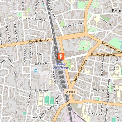
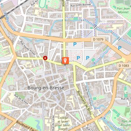
Departure from Brou church (46.1979, 5.2353 *).
The route skirts the SE monastery along the Hélène de Savoie alley to the Boulevard Charles de Gaulle, which you cross at the crosswalks to take the chemin de la providence. After 700m, turn left onto the track leading down to the Reyssouze under the high-voltage power lines to the entrance to Parc de Bouvent. Then take the chemin du lac, pass under the bypass, the chemin de Bouvent, still on the cycle track, and the route de Revermont for 800m, which is dangerous because there is no shoulder.
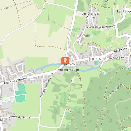
At Bois des Bletonnées, turn right (SW): Chemin de la Goyatière then left-right into Chemin du Gourd (SSE). Cross the Reyssouze then, at the end, turn left onto the Montagnat village road. 2nd right, take the Chemin de la Craz down to the pond. Cross the Reyssouze again, then turn 3rd right onto chemin de la fruitière. At the end, left-right, follow the old wall of Château de Rivoire on chemin de Ravary to cross (SE) the A40 freeway. Continue along the Reyssouze, crossing it at "le Montet". At the end of chemin du Montet, turn left onto chemin de Mas Cruzin, where you cross the Reyssouze again and continue to the Tossiat cemetery. Turn right onto the route de Montagnat, then left onto the route de Journans to the village entrance. Take the small footpath around the large bend to rue du moulin for 50m. At the moulin(1), turn right onto chemin de la mine, then chemin des feuillées de Tossiat (GR®59 and GRP® tour du Revermont). At the fork, still on the GR®, turn left onto the Chemin du Fayet. At the end of the descent into the hamlet of Fayet, turn right onto chemin de la tour, then slightly right above a Cerdon winegrower onto a track.
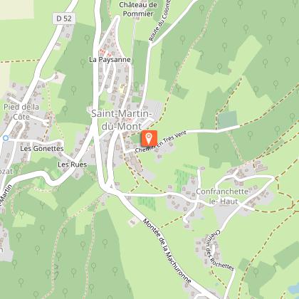
Cerdon winegrower. At the end of the descent, take the road on the right, then the 1st path on the left to Saint-Martin du Mont(2), a stopover village. The gite d'étape (sleeps 8) is on the left 300 m after the cemetery. The Gite de France, formerly the presbytery, is behind the church.

Day 2:
Leaving the village, take rue de la mairie (S) towards Place des anciens combattants. Go slightly downhill to the left to take the "montée de la Machuronne" road to the hamlet of "Confranchette d'en bas". At the hamlet's crossroads, turn right towards "Crozat", then leave the Turgon road on the left onto a wide track that joins the Suran river at "les Cochatières". Stay on the "Moulin des Craipes" road until you reach the Suran bridge, which you must cross to go up (SE) towards Saint André, the freeway and Pampier (on the GR P® Tour du Revermont to Pont d'Ain). At the bus stop, take (S) route de la ville for 700m, turn right onto chemin du Solliat, then left at the end onto avenue Philibert le beau for 250m.
Still on the GRP ®, turn right towards the Catherinette chapel. Continue along this wide track to the "montée des Jouberts" path, which leads down to rue Louise de Savoie, where it continues eastwards for 50m. Turn right down the staircase to the downstream end of the old mill, then join the banks of the River Ain as far as Quai Justin Reymond, then take the staircase to the bridge. After crossing the Ain, take the left-hand sidewalk and go straight ahead, following the cycle path, to the Pont Rompu roundabout. From there, left to the Super U roundabout, then right on rue de la Batie.
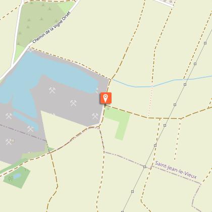
At the next roundabout, turn left to go around the Maison du fromage and find yourself on the RD1084. Take a sharp right (south) past a field of solar panels to Chemin de la Vigne Orset, opposite the quarry ponds. Turn left on this path for 200m, then right for 600m at the signs (history, flora and fauna), then right again to continue around the pond. 200m further on, you'll see the Via Lugdunum markings(3) in the direction of Ambronay.
The rest of the via Lugdunum itinerary is described in the red guide. The markings become classic from the junction

Technical Information

Walking
Difficulty
Medium
Duration
8h40mn
Dist.
33 km
Show more

Altimetric profile

Starting point

Boulevard de Brou , 01000   Bourg-en-Bresse
Lat : 46.198113Lng : 5.234858

Points of interest

image du object

Bourg-en-Bresse station

The station is located close to Bourg-en-Bresse city center. The station's main entrance is on the east side of avenue Pierre-Semard, while the west entrance is on rue du Peloux.The station has a passenger building with ticket offices and a waiting room, open every day. It is equipped with automatic machines for the purchase of TER tickets. It is an "accès plus" station, with facilities, equipment and services for people with reduced mobility. Station services include - a restaurant - bar, - a Relay press store, - a car rental service - and a bicycle rental service. Bourg-en-Bresse is served by TGV Lyria high-speed trains on the Paris-Gare-de-Lyon - Bourg-en-Bresse - Bellegarde - Genève-Cornavin - Lausanne route. TER Auvergne-Rhône-Alpes trains take 45 minutes to get from Bourg-en-Bresse to Lyon, via Ambérieu-en-Bugey and Meximieux. The journey through the Dombes region takes 1 hr 15 min. It's also an important regional station in the TER Auvergne-Rhône-Alpes network, on the Lyon-Perrache - Bourg-en-Bresse - La Cluse - Oyonnax - Saint-Claude route, and the origin of connections to : Lyon-Perrache (via Lyon-Part-Dieu), Roanne (via Villars-les-Dombes and Lyon), Mâcon-Ville, Besançon-Viotte (via Lons-le-Saunier), Belfort (via Lons-le-Saunier and Besançon-Viotte), Dijon-Ville (via Saint-Amour and Louhans), Chambéry - Challes-les-Eaux (via Ambérieu-en-Bugey, Culoz, Aix-les-Bains-Le Revard). A bicycle park (with collective lockers and free-access bicycle hook-ups) and a parking lot are located in the immediate vicinity. A Rubis'Vélo self-service bicycle station, Semard Gare, is located in the immediate vicinity of the station. It is served by Rubis network buses on routes 1, 2, 3, 5, 21, 115, 150 and Rubis'City, and by Cars Région Ain coaches.

12 avenue Pierre Sémard 01000 Bourg-en-Bresse
- Bourg-en-Bresse destinations - Office de tourisme -
Consulter
image du object

Rubis Grand Bourg Mobilités

Bus, bike, free shuttle, school transport, transport on demand, transport for people with reduced mobility or carpooling: all your travel needs within the 74 communes of Grand Bourg Agglomération.The Rubis network comprises 8 mobility packages: - Rubis urban network: 7 urban lines (numbered 1 to 7) serve the towns of Bourg-en-Bresse, Péronnas, Saint-Denis-lès-Bourg and Viriat from Monday to Saturday, including : 3 routes (1 - 2 - 3) with a frequency of 12 minutes from Monday to Friday, and 20 minutes on Saturdays and during vacations 4 lines (4 - 5 - 6 - 7) with a frequency of 20 to 30 minutes all year round - Rubis suburban network: 3 suburban lines: Route 10 serves the towns and neighboring towns of Montrevel-en-Bresse, Bourg-en-Bresse and Ceyzériat, with an average frequency of one bus per hour. Route 11, serving the communes of Polliat, Bourg-en-Bresse and Saint-Etienne-du-Bois, with 6 round-trips per day. Route 12, serving the communes and neighboring communes of Val-Revermont, Meillonnas, Jasseron and Bourg-en-Bresse, with 4 round trips per day. - Rubis' Junior: more than 145 routes throughout the region to transport pupils from the 74 communes on school days. - Rubis' City: A free 100% electric downtown shuttle with hop-on hop-off service, running every 20 minutes Monday to Saturday from 10 a.m. to 6 p.m. - Rubis' Vélo: 100% electric self-service bicycles. 45+ stations available in Bourg-en-Bresse, Péronnas, Saint-Denis-les-Bourg and Viriat. - Rubis' Plus: Transportation on demand by reservation, divided into 4 geographical sectors, from 6:00 to 9:30 am, from 12:00 to 1:45 pm and from 4:00 to 7:00 pm, Monday to Saturday, excluding public holidays. Reservations can be made via the Rubis'Plus app or by phone. - Rubis'Plus Time: On-demand transport on reservation, when the bus network is not running (early morning, late evening) and on Sundays and public holidays. From 4:30 am to 6:30 am and from 8:30 pm to 11:00 pm from Monday to Saturday, and from 8:00 am to 9:00 pm on Sundays and public holidays (except May 1st). Reservations can be made via the Rubis'Plus app or by phone. - 2 car-sharing services : BlaBlaCar Daily: Grand Bourg Agglomération's daily commuting application. It's simple, user-friendly and rewarding for drivers! Rubis'Covoit' Ligne: 8 free, no-reservation carpooling routes in the communes of : Bourg-en-Bresse, Viriat (Hôpital Fleyriat), Jasseron, Lent, Servas, Marboz, Polliat, Montrevel-en-Bresse, Attignat, Ceyzériat, Saint-Just and Saint-Etienne-du-Bois. It's free, supportive and local! + Find out more about the Rubis network on the Rubis mobile app and at www.rubis.grandbourg.fr

Immeuble Paul Claudel 2 rue du 19 mars 1962 01000 Bourg-en-Bresse
- Bourg-en-Bresse destinations - Office de tourisme -
Consulter

Additional information

Environments

In the country
Close to a motorway
Forest location
Mountain view
Close to a public transportation
View over the vineyards
10 - 20 min walk from train station
Less than 10 minutes from a train station by car
20 - 30 min from bus stop by car

Updated by

Bourg-en-Bresse Destinations - Office de tourisme - 24/11/2025
www.bourgenbressedestinations.fr
Report a problem

Open period

All year round daily.

Type of land

Groomed trail
Stone
Grit

Ratings and reviews

To see around
See more
Open
Close
Show
Show
Show
Show
Show
Show
Show
Show
Show
Show
Show
Caution!
We have no information on the difficulty of this circuit. You may encounter some surprises along the way. Before you go, please feel free to inquire more and take all necessary precautions. Have a good trip! 🌳🥾