Le Grand Tour du Mont-Chéry et variante
Description
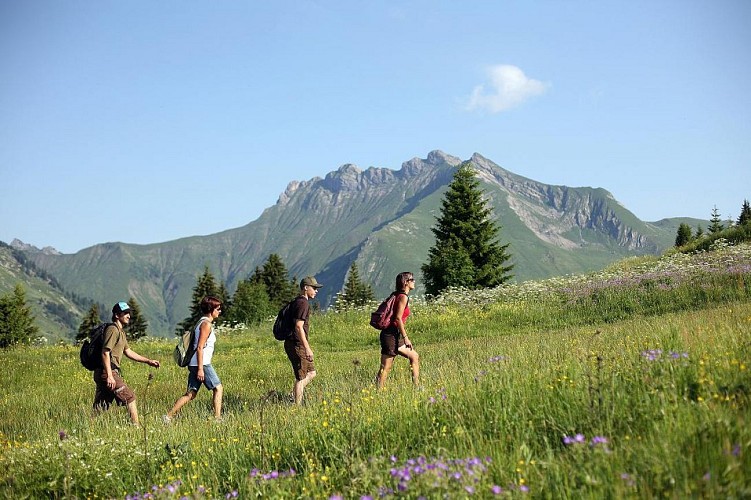
This walk allows you to discover the whole of the Mont-Chéry area; you will appreciate the contrast between the south and north-facing sides. The alternative route allows you to rejoin the Lachat mountain pass, from where there is a superb view of the Mont Blanc mountain range and the Prealps. Watch out for the technically challenging sections where the path is narrow and sometimes slippery.
LE GRAND TOUR DU MONT-CHERY
DURATION: 4 hrs 30 mins
ALTITUDE DIFFERENCE: / 500m ascent, 870m descent
DISTANCE: 12.4km
LEVEL OF DIFFICULTY: 3/3
DEPARTURE POINT: top of the Mont-Chéry gondola lift
ARRIVAL POINT: Les Gets village
ALTERNATIVE ROUTE :
DURATION: 4 hrs 30 mins / 4 hrs 45 mins
ALTITUDE DIFFERENCE: 590m ascent, 960m descent
DISTANCE: 12.8km
LEVEL OF DIFFICULTY: 3/3
DEPARTURE POINT: top of the Mont-Chéry gondola lift
ARRIVAL POINT: Les Gets village
Technical informations
12 km
|
min. 99999 m
590 m
960 m
| |||
Altimetric profile
Starting point
Additional information
Updated by
SAGETS - 03/04/2024
www.lesgets.com
Report a problem
Open period
From 15/06 to 08/09 : open daily from 9 AM to 5.30 PM.
Contact
Phone : 0450758080
Email : lesgets@lesgets.com
Website : www.lesgets.com
Data author

The Cirkwi brief
Discover the stunning landscapes of Mont-Chéry on a journey crafted by Apidae. This path offers a unique way to experience the contrasting slopes of ubac and adret while soaking in the panoramic beauty of the Mont Blanc range and the Prealps. Perfect for adventurous souls, this itinerary encapsulates the essence of the French Alps, marrying breathtaking scenery with the charm of Les Gets village. As you traverse this carefully outlined route, let the alpine ambience embrace you, offering a blend of exhilarating challenge and tranquil beauty.
Brief Technical Overview
This route begins at the Mont-Chéry gondola's arrival station and ends in the village of Les Gets. It covers a distance of 12.8km, with an ascent of 590m and a descent of 960m, rating a 3/3 in difficulty. The variant path slightly modifies the journey, spanning 12.4km, ascending 500m, and descending 870m. These metrics provide a rigorous yet rewarding experience for hikers, emphasizing its fitness requirement and terrain challenges. Clearly, this itinerary is designed for those seeking an intense connection with the mountain terrain.
Seasonal Tips and Safety
For a safer and more enjoyable hike on Mont-Chéry, consider the seasons. Summer offers clear paths and warmer weather, ideal for appreciating the lush scenery and reaching the panoramic viewpoints. Winter hiking requires caution and possible gear for snow-covered paths. Whenever you venture out, ensure you're well-prepared with water, appropriate footwear, and layers to adapt to sudden weather changes. Also, booking ahead at Les Chevrelles, especially for larger groups, will guarantee a delightful culinary stop along your journey. Respect nature, stay on marked trails and start early to fully enjoy your adventure.
Les Gets: Heart of the Alps
Nestled within the Haute-Savoie department, Les Gets is more than just a starting point for the Mont-Chéry hike; it's a historical and cultural gem in the Rhône-Alpes region. This village, with roots stretching back to the 11th century, has transformed from a modest farming community into a renowned alpine resort without losing its authentic charm. The area's commitment to preserving its natural landscape and heritage makes it a compelling destination for those looking to explore the Alpine culture deeply.
Understanding Regional Weather
The general climate in Les Gets is Alpine, characterized by cool summers and cold, snowy winters. This makes the summer months, from June to September, the most favorable for hiking adventures, when the weather is mild and the paths are mostly snow-free. Winter presents a magical snowy landscape, ideal for snowshoeing or skiing, although the hiking paths would require careful preparation. The transition seasons, spring and autumn, can be unpredictable, with occasional showers and fluctuating temperatures, prompting hikers to come well-prepared for any condition.